Archive Page 8

Important Milestones DWR is conveniently forgetting

A California Department of Water Resources (DWR) Scoping Meeting Slide:

Some of us would like to start with some earlier milestones:

  • June 8, 1982 – The voters soundly reject the California Proposition 9, the Peripheral Canal Act.
  • August 27, 2014 – DWR announce postponement of the BDCP Tunnels due to comments received. “The comments revealed that certain areas of the plan need additional study.”
  • August 28, 2014 – The EPA submits a 43-page report warning that the Delta Tunnels could violate Federal law.”
  • July 10, 2015 – Revised BDCP Plan (now called the “California Water Fix”) was released with only the Tunnel portion. Another plan, “EcoRestore” is the habitat restoration plan. [Comment: Has anyone heard anything about EcoRestore in the last five years? Crickets.]

Ah well, bygones. The list of key milestones presented by the Department of Water Resources (DWR) at the beginning of each of their Single Tunnel Scoping Meetings begins:

  • July 2017 – DWR approved a two-tunnel conveyance project (California WaterFix).
  • February 2019 – Gov. Newsom announced support for a single tunnel conveyance project.

Wait a minute here. That leaves out some very pertinent milestones.

  • November 2018 – The Delta Stewardship Council Staff recommended that WaterFix failed to meet the requirements to be incorporated into the Delta Plan. The certification for the Delta Plan was a requirement before DWR could obtain their permit for the tunnel intakes in the north. The plan should be remanded to DWR to fix. This was a big win for STCDA and others. Why did the Staff say not to sign off on WaterFix?
    • DWR didn’t use the latest “Best Available Science.”
    • The water suppliers hadn’t addressed “Reduce Reliance on the Delta through Improved Regional Water Self- Reliance.”
    • California WaterFix will have a significant adverse environmental impact.
    • WaterFix desn’t meet the Delta flow objectives.
    • And the biggie: WaterFix conflicts with land uses in existing Delta communities, conflicts with existing land uses due to impacts on cultural and historical resources, conflicts with existing Delta parks and recreation uses, traffic impacts, and conflicts with existing land uses due to noise impacts.

    The Staff recommended that the Council remand the matter to the Department for reconsideration.

  • December 2018 – Rather than wait for WaterFix to be officially ruled as “inconsistent” with the Delta Plan (hence unable to be built), DWR withdrew its certification request.

They ignored those two major milestones, significant wins for STCDA.

Then yes, in May 2019 DWR finally withdrew WaterFix. Up until that time, DWR had still been trying to pretend one tunnel would “fix” the problems with the twin tunnels and trying to move forward without writing a new plan or new Environmental Impact Report (EIR). But taken before a judge, it was clear that DWR couldn’t have it both ways. The DWR finally accepted the fact that they would need to write a new plan and a new EIR. In January they issued the Single Tunnel Notice of Preparation.

But wait . . . they didn’t “rewrite” the plan. The new plan has the same issues as the old, rejected plan. How does simply going from two tunnels to one solve the problems? Unless the Eastern Corridor is selected, all of the in-Delta impacts remain the same. And regardless of tunnel route, the impacts to the legacy communities in the North have not been corrected.

As far as “Reduced Reliance on the Delta through Improved Regional Self-Sufficiency,” a tunnel will never do that. A tunnel will increase reliance.

For L.A. to improve regional self-sufficiency, there needs to be a ten-year goal to stop pumping Delta water up over the Tehachapis to L.A. The State Water Project is the biggest consumer of electricity in the state yet, ironically, a priority of the Single Tunnel objectives to address climate change. The Delta water should be replaced with desalination, recycling, and conservation, such as replacing L.A.’s lawns with drought-resistant landscaping.

The Central Valley can reduce reliance on the Delta by desalination for Santa Barbara which now uses Delta water pumped over the coastal range. Some have proposed pumping ocean salt water pumped to the Central Valley to desalination plants there. There are plenty of areas in the Central Valley with damaged land laced with salts and selenium. More salt from a desalination plant will not be an environmental issue there. But of course, the Central Valley’s biggest issue is the loss of their aquifers. The Tulare Lake used to provide a natural percolation pond effect for those wells. At times of high rain, we should implement an approach to recharge ground water. Santa Clara Valley Water District has a good approach using Vasona Lake (water from Lexington Reservoir) as both a percolation pond and a nice park. A Tulare Lake replacement is needed. And, of course, a logical change would be to better manage what crops are right to be grown in the arid desert land there instead of orchards and almonds. To quote Dr. Michael, “As water becomes more scarce, but it may be less costly and more efficient to move crops, farm workers, and capital to more water rich locations in the Valley than it is to move water long distances out of watersheds.”

There are better alternatives to a tunnel that need to be evaluated.
Last Night’s “No Tunnel” meeting in Brentwood

First – a big thank you for everyone who showed up. We overfilled the room, standing room only. At least 100 people. We will post the pictures of the gathering before the meeting with our “No Tunnel” signs and banners.

Second, a big thank you to everyone who got up and made comments. The comments were awesome.

And last but not least, a huge thank you to our champion, Michael Brodsky, STCDA’s Legal Council, who drove up from the Santa Cruz area to attend the meeting.

Here is a video clip (thanks to Bill Wells) from last night’s meeting with Michael Brodsky, STCDA Legal Council, making his comments. Brodsky stated that he wants to propose alternatives that fully achieve the project objectives where a tunnel doesn’t and with much less environmental impact than the tunnel.

Here is the entire video, thanks to Gene Beley.

The stated [Single Tunnel] project objectives are:
First, to mitigate the effect of levee failure in case of earthquake which would cause salt water to rush in and endanger water supplies. The alternative to a tunnel is the common sense answer of strengthening the levees including with setback levees and channel margin habitat that have an environmental benefit and a dual benefit of protecting water supplies.

The second objective of the project is to mitigate sea level rise caused by climate change. That can be mitigated in several ways, the most obvious of which is to allow more water to flow through the Delta and out to the sea to push back salt water. And where does that water come from? It comes from stopping exporting water over the Tehachapi Mountains which also achieves the project objective of making the SWP deliveries more reliable. They’re not reliable because you’ve promised too much water in too many places.

Why do we stop it over the Tehachapis? Because the State Water Project consumes all of the electricity generated by all of California’s hydroelectric dams plus 4 or 5 billion kilowatts of gas fired carbon-emitting power each year. The State Water Project is a climate atrocity. Gavin Newsom has to face up to that. You are required by the Public Trust Doctrine to exercise a continuing duty of supervision in the public interest. And it’s obvious that the place of use in your water rights permits south of the Tehachapi Mountains must be amended so that that place of use is eliminated.

So one of the portfolio elements will contain a planned retreat from exports south of the Tehachapi Mountains, phased out over ten years.

Other elements that are included that do not include a tunnel, as I mentioned before, would be flooding some of the islands, some of the islands the levees can be strengthen, others can be sacrificed and those islands can be flooded for habitat and also as a barrier to salt water intrusion.

And you weren’t telling the truth when you said decisions weren’t made. The Notice of Preparation defines the range of alternatives. It has been written to exclude everything except Delta conveyance. So the major decisions have been made before you go to these scoping meetings.

But we are going to insist that you study non-tunnel alternatives.

What will L.A. do without the Delta water?

Many comments addressed this, and stressed that with California bordering the ocean, an obvious solution is desalination and other more modern technologies than a tunnel.

Jan McCleery’s comments included this:
In 2009 (prior to the WaterFix/Twin Tunnels) the BDCP rejected the desalination alternative saying it was too expensive. In 2013, Dr. Jeffrey Michaels at the University of the Pacific wrote about advancements in desalination technology making it cheaper and more effective. It’s now 2020. The EIR should study as an alternative to a tunnel, a retreat from exporting Delta water over the Tehachapis, replacing that water with new sources from desalination, recycling, conservation, and replacing lawns with desert landscaping. In other words, LA should reduce reliance on the Delta through improved regional self-reliance. Replacing lawns with desert landscaping would save more water than is annually diverted from the Delta. This is common sense conservation.

(Note: The 2009 Delta Plan requires “reduced reliance on the Delta through improved regional self-reliance.)

Side-Note about Reservoir and Habitat Islands

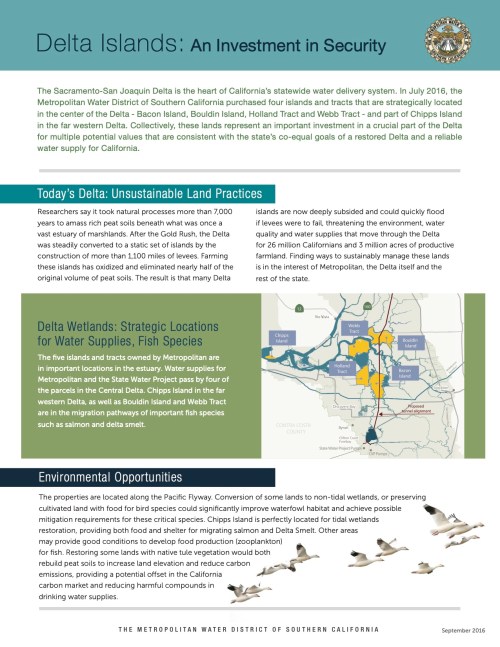
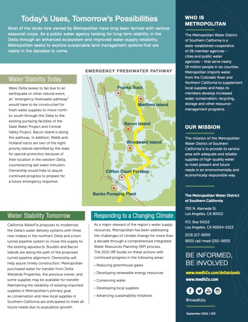
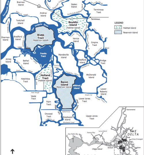
Mr. Brodsky referred to islands in the Delta that can be flooded or used for habitat. Four Delta Islands were purchased in 2016 by Metropolitan Water District were initially purchased as part of a project where two would be flooded as in-Delta reservoirs (Bacon Island and Webb Tract) and two would be modified as habitat islands (Holland Tract and Bouldin Island). See map below:

Metropolitan Water District put out a glossy describing what they planned to do with these islands to improve the Delta:

Of course, none of that has happened.

“New” Tunnel Plan, Same Problems

Here’s an overview of how the “new” Single Tunnel Plan is the same as the old plan. And what is different (not much).

The only difference is a possible new Eastern route which goes a bit more around-the-Delta than through it. But other than a swath of purple on a map, there are no details yet about construction impacts with an Eastern tunnel route.

Otherwise, the same construction impacts exists at the North intakes and along the old Through-Delta route (still an option). In addition, regardless of tunnel route, the construction will leave behind muck in the Delta plus the same long-term water quality issues exist.

DCA Engineer said not to worry about gas fields in the tunnel route

Say what?

The “Central Corridor” tunnel route goes through the largest natural gas field in California, the Rio Vista gas fields. At the Stakeholder Engagement Committee Meeting on Wednesday, February 12, Karen Mann, South Delta Local Business representative, asked the Delta Conveyance Design and Construction Authority (DCA) engineer about how they tunnel through gas fields.

She asked, “Don’t you build a tunnel in a straight line?”
Kathryn Mallon, lead DCA Engineer, answered, “Yes that is what we like to do.”
Karen then asked, “What happens if you accidentally pierce a gas or water pocket underground.”
The engineer presenting the slides replied that the gas was 1,000 feet underground so no worry.

Really?


Rio Vista Gas Fields

DCA is an organization established by the water contractors, primarily Metropolitan Water District (MWD), assigned to work on the design of the Single Tunnel project.

MWD has a history of ignoring risks. MWD ignored warnings of gas fields when tunneling the Sylmar Tunnel from the Castaic Reservoir (which is Delta water) to L.A. First came the smell of gas, then the blast that killed 17 miners deep beneath the San Fernando Valley neighborhood of Sylmar.

MWD is again ignoring the risk.

For more details on tunneling through gas fields, please see California Water Research’s report on Tunnel Construction and Gas Wells

Unacceptable – Single Tunnel Plan has the same Intake Locations in the North!


Karen Mann at the Stakeholder Engagement Meeting February 12, 2020.

At the Wednesday Stakeholder Engagement Committee Meeting, Karen Mann, representing South Delta Local Businesses, read feedback from one of her stakeholders explaining why we are enraged that the new Single Tunnel Plan has the same intake locations in the North Delta:

It is clear that the intakes cannot be placed in any of the locations shown on the preliminary drawings for discussion purposes (that is in 2 of the 3 locations of previous intakes 2, 3, and 5 of California Waterfix). Extensive evidentiary showings in the prior State Water Resources Control Board hearings and Delta Stewardship Council hearings show that neither of these agencies can approve intakes in these locations because it would not be consistent with the Public Trust Doctrine (Water Board) or the Delta Reform Act (Delta Stewardship Council). It is unacceptable to locate the intakes in close proximity to Delta Legacy communities. We understand that DWR wants to put the intakes in these locations only because they claim they have an existing water right at these locations. DWR will just have to accept the reality that they are going to have to put the intakes somewhere else and initiate a new water right in order to do so.

The question is: When will begin a realistic consideration of intake locations? That is, locations other than currently being considered. Talking about intakes at the current locations is a waste of time because it cannot happen.

That sentiment is similar to what we’re saying in addition about the “Central Corridor” tunnel route (which is the same as the WaterFix “Through-Delta” Alignment) which we proved in the prior Water Board hearings and DSC hearings that the shutting down of Delta waterways to boating and recreation was inconsistent with the Delta Plan and could not be approved. Talking about construction destruction through the center of the Delta is a waste of time.

In addition, nothing has changed with the long-term issues raised about impacts to the in-Delta water quality. You can’t take the fresher water out before it flows through the estuary and expect improvements for fish survivability.

Yet, DWR moves ahead with these “Scoping” meetings expecting community input.

Why aren’t they taking the input they previously received and altering their plan to make it acceptable?

REMINDER ***CALLING ALL HANDS

Thursday, February 20, 2020, 6 p.m. – 8 p.m. Brentwood Community Center Conference Room, 35 Oak Street, Brentwood. South Delta members are STRONGLY requested to attend !!! We will be in the parking lot at 5:15 p.m. to organize.

If you can’t make that one, there is one on Wednesday, February 19, 2020, 6 p.m. – 8 p.m. Clarksburg Middle School Auditorium, 52870 Netherlands Road, Clarksburg.

Get your new “No Tunnel” Lawn Signs now

Get your new “No Tunnel, One Tunnel is One Too Many!” signs now. Here’s our President, Karen Mann, modeling our new sign:

Our old “Stop the Tunnels” lawn signs became out of date when the WaterFix twin tunnel project was rejected. But the Single Tunnel project continues. Some of our members were trying the use black Sharpies or electrical tape to “X” out the “s” on Tunnels. We’ve got that fixed. We will replace your old sign for free and want as many of you to have signs who will display them!

To request a lawn sign, Click Here to send an email to the lawn sign committee.

We also are asking for volunteers who will take signs to neighbors who have the old signs to replace them and ask people without signs if they want one. Let our sign committee know if you can help. Click Here to send an email to the lawn sign committee to volunteer.

Don’t Rip Up the Delta! Tunnel Maps show the New Plan is the same as the Old Plan

The California Department of Water Resources (DWR, or “the State”) released limited detail with their recent Single Tunnel Notice of Preparation (NOP). But the map they did release is very worrisome.

Our new Tunnel Maps page under More Info… consolidates in one place the “new” Single Tunnel map, all of the old maps we have submitted over the years, plus we’ll add new maps as we receive them.

This blog is a review of the issues with WaterFix (which were backed up by expert testimonies). But before the Judge could rule in our behalf in the Spring of 2019, DWR took their WaterFix and ran. Now they are back with the same old plan. (And one new variation.) So let’s review the facts.

In the North Delta

There is virtually no change to three proposed tunnel intake locations that would destroy the historic community of Hood and significant impact to Clarksburg and Courtland. (Only two intakes would be built, but the State omitted sharing which two.) Delta representatives proved beyond the shadow of a doubt that WaterFix would be disastrous to those communities. The town of Hood would be overrun by pumps and construction for 13 years! Pile driving 24×7 would mean the kids in the Clarksburg school right across the river couldn’t hear their teachers voices for 13 years! Old historical communities like Locke could not withstand the vibrations of construction trucks roaring 24×7 down their narrow roads. The Delta Protection Committee said WaterFix would cause “blight” on these communities. Significant impact.

Condemnation.

What we deserve is details from the DWR about how this new plan would protect and enhance the historic legacy communities in the North.

In the South Delta

The State is still considering the destructive Through-Delta Alignment (now renamed the “Central Corridor”). STCDA brought expert witnesses to testify that the main highways throughout Contra Costa County would be gridlocked with construction trucks. The complete gridlock that would occur throughout CCC would make it impossible for Delta farmers to get their produce to market safely and would block products, services, and commuters from traveling between CCC and Stockton.


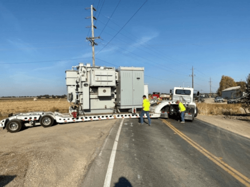
Check out the big rig stuck on Twin Cities Road. It’s one of the haul routes for the Delta tunnel. The Delta and its narrow levee highways are no place for construction trucks!

To compound the issues, the State planned to use barges throughout the waterways. The large tugs pushing the barges would require Delta bridges to open, such as Highway 4 that now doesn’t open would have approximately eight openings per day. The logistics of a huge construction project in an area of farm islands surrounded by waterways and minimal roads was obviously never studied by the DWR.


The Delta is no place for Construction and Cement Trucks – Wheels up!

Our maps specifically point out key waterways important for Delta boating and recreation coupled with the construction destruction maps in the WaterFix plan for those favorite waterways. We’ve repeatedly try to make the DWR consider favorite boating and recreation waterways and the impact of losing those to the boating communities in the Delta.

But the barges, huge docks, and 24×7 construction plan ignored testimonies that proved the barges and construction would basically shut down boating in the Delta for 13 years. Marinas would close, boaters would go elsewhere, boating and fishing communities would be economically ruined. This was proven. Yet their new plan has the old destructive Through-Delta route as one of the alternatives still on the table.

The State should review our maps, not ignore them

The Delta communities have spent ten years explaining to the DWR why their WaterFix plan was unconscionable. Now they are starting scoping meeting asking us to tell them once again?

To review the maps

Review the maps to be reminded why the Through-Delta or “Central Corridor” work will destroy the South Delta. Click Tunnel Maps page under More Info… This information has been part of STCDA’s formal comments and testimonies for ten years.

A new Eastern Corridor alternative?

The NOP includes a tunnel route further east, the “Eastern Corridor.” The details are missing on their map.

In Summary

The State owes us a report detailing that route and detailing the logistics of trucks and supplies to that new Eastern route: Will they still flood the waterways with barges and the small Delta levee roads with construction trucks? Or do they have a more viable construction plan. That is the information Delta communities deserve to hear from the DWR in the scoping meetings to know how bad the impacts are from an Eastern Route.

Regardless, there is no change between Central or Eastern route for the North Delta legacy communities (the intake locations are the same either way). And it is unclear how either route would affect Victoria Canal, one of the important recreational sloughs for the South Delta.

Public Scoping Meetings

The list of scoping meetings is maintained on our Event Tracker tab. They are also listed below.

Single Tunnel Public Scoping meetings are scheduled to take place at the following times and locations:

  • Monday, February 3, 2020, 1 p.m. – 3 p.m. California Environmental Protection Agency Building, 1001 I Street, Sacramento
  • Wednesday, February 5, 2020, 6 p.m. – 8 p.m. Junipero Serra State Building, 320 West Fourth Street, Los Angeles
  • Monday, February 10, 2020, 6 p.m. – 8 p.m. Jean Harvie Community Center, 14273 River Road, Walnut Grove
  • Wednesday, February 12, 2020, 6 p.m. – 8 p.m. Santa Clara Valley Water District Board Room, 5750 Almaden Expressway, San Jose
  • Thursday, February 13, 2020, 6 p.m. – 8 p.m. San Joaquin Council of Governments Board Room, 555 Weber Avenue, Stockton
  • Wednesday, February 19, 2020, 6 p.m. – 8 p.m. Clarksburg Middle School Auditorium, 52870 Netherlands Road, Clarksburg
  • Thursday, February 20, 2020, 6 p.m. – 8 p.m. Brentwood Community Center Conference Room, 35 Oak Street, Brentwood

Anyone interested in more information concerning the EIR process, or anyone who has information concerning the study or suggestions as to significant issues, should contact Marcus Yee at (916) 651-6736

We Need your Help!

(Updated 1/27/2020)
I know you are saying, “Once again? More meetings and comments?”

But this is going to be the final round! The “knock-out punch.”

And we’ve made such progress by stopping the Twin Tunnels last year. And many of our winning arguments against that plan are still valid today.

We plan to attack the Single Tunnel Plan on three prongs:

  1. One – The location of the Intakes in the North Bay are atrocious. They will cause blight on the legacy communities to the North. We don’t have details yet on this new plan, but the basic location hasn’t changed and is right on top of the towns of Hood, Courtland, and Clarksburg.
  2. Two – We fought valiantly that the Through-Tunnel Construction Project was a show-stopper. The Department of Water Resources (DWR) has now come back with two alternate routes – the old ridiculous through-tunnel route (now re-labeled the “Central Corridor.”)

    (The DWR are experts at marketing/re-labeling attempts. “Muck” was re-labeled “Reusable Tunnel Material (RTM).” Doesn’t that sound nice. And the “Through-Delta Alignment” now becomes the “Central Corridor.” Not to mention the original plan was named the BDCP “Bay-Delta ‘Conservation’ Plan.” And then because the EPA said it wasn’t a “Conservation” plan, it was relabeled “WaterFix.” Sounded better than a “Tunnel Plan.”)

    We proved that their Through-Delta route would cause significant impacts to boating and recreation throughout the Delta, and to Delta communities’ roads and services. The DSC Staff reported that route was inconsistent with the Delta Plan, which should have been a show-stopper. But yet it is still one of the routes being considered.

    Now they are offering an “Eastern Corridor” as a “maybe” option.

    This is where we need your help.

    We have a great amount of detail about the impacts of the Central Corridor. You can review that information on our new Tunnel Maps page. Those maps highlight favorite South Delta boating & recreation channels and show how the Central Corridor construction plan wipes them all out.

    So now we need to analyze the Eastern Corridor to see what the issues are there.

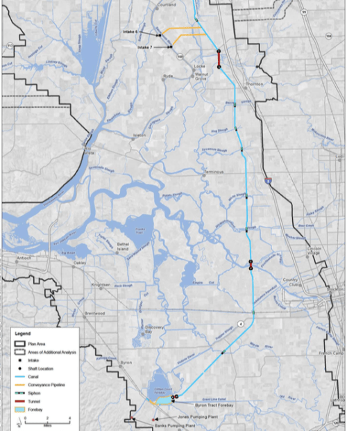
    We need your help to identify if the Eastern route has issues and what they are. To that end, we have their new 2020 map and added labels for what boating sites are in the Eastern route path. Below that is their old Eastern Route which has more detail about the actual tunnel path and tunnel shaft locations. These may have changed, but it’s the best we have to-date. If you have traveled those waterways, please email me with any info you have. jmcccleery@duckpondsoftware.com.

    NOTE: The map below is an image and the labels are hard to make out. For a more readable version of the map click here.

  3. WaterFix Eastern Alignment. I think this map is outdated – but may help visualize where a tunnel and tunnel shafts would go.

  4. Three – Resulting water quality. We do not believe that either alignment proposed will improve the real issues that affect the water quality which impacts the environment, the fish, and results in invasive plant species including toxic blue-green algae. We have our arguments ready there.

We will be asking for your help with attending the scoping meetings (yes, sorry, we need to show up again. Thank you in advance.) The list of meetings is here: https://nodeltagates.com/event-tracker/

They think we’re tired and won’t show up again.

The best message would be for as many as possible to show up for the first meeting in Sacramento:

  • Monday, February 3, 2020, 1 p.m. – 3 p.m. California Environmental Protection Agency Building, 1001 I Street, Sacramento

We’d like folks to support the communities in the North Delta that will be inundated with the intakes and pumping facilities. Those meetings are here:

  • Monday, February 10, 2020, 6 p.m. – 8 p.m. Jean Harvie Community Center, 14273 River Road, Walnut Grove
  • Wednesday, February 19, 2020, 6 p.m. – 8 p.m. Clarksburg Middle School Auditorium, 52870 Netherlands Road, Clarksburg

Those of you who are in San Jose or LA – here’s the meetings there:

  • Wednesday, February 5, 2020, 6 p.m. – 8 p.m. Junipero Serra State Building, 320 West Fourth Street, Los Angeles
  • Wednesday, February 12, 2020, 6 p.m. – 8 p.m. Santa Clara Valley Water District Board Room, 5750 Almaden Expressway, San Jose

There’s one in Stockton:

  • Thursday, February 13, 2020, 6 p.m. – 8 p.m. San Joaquin Council of Governments Board Room, 555 Weber Avenue, Stockton

Show them Discovery Bay and the South Delta Communities are still committed!

We want all of our South Delta members to also attend the meeting nearest to Discovery Bay. Remember how we flooded the DSC meeting a couple of years go and they had to expand the conference room and ran out of sign-up sheets? We want to do that again:

  • Thursday, February 20, 2020, 6 p.m. – 8 p.m. Brentwood Community Center Conference Room, 35 Oak Street, Brentwood

Support us and show up for as many meetings as you can. Particularly the first and last.

And we will be asking you to send in comments. We’ll send out more info about that soon.

Even the “Big Guys” are jumping into the fray

Photo by the Department of Water Resources
Here’s a very good, strong letter written by the Sierra Club opposing the tunnel and reprimanding Newsom for his water policy directions.

Here are some excerpts but it’s worth reading the entire email here.

First, the governor is on a track that seems driven by adherence to some of Governor Jerry Brown’s worst water policies. And, second, he’s not getting good advice.

As they did with Brown, the bad water policies related to the San Francisco Bay Delta and a tunnel are overshadowing the good water policies the administration is advancing.

Newsom’s water problems started on election day in 2018, even before votes had been counted in the governor’s race. That day, as lieutenant governor, he signed onto a letter with then-Governor Brown, instructing the State Water Board chair to postpone a public hearing set for the very next day about new water rules affecting rivers that flow into the Delta.

Furthermore, about those Delta flow rules recommended by the Water Board that were backed by environmentalists and supported by science, Newsom’s approach is to let the big water contractors opt out by agreeing to a “voluntary agreement” approach. I liked their analogy:

To put that in perspective, when a big water contractor asks for a voluntary agreement, it’s kind of like a kid asking for free run of a candy shop. Forever.

And here’s their critique of Newsom’s water policies in general:

On the one hand, he signed an executive order that promises to make regions more water resilient and develop a portfolio of needed projects.

On the other hand, his administration produced a draft portfolio that relies on—wait for it—the Delta tunnel, the epitome of non-regional non-resilience.

It’s a good read.

Click here to read their entire email.

RBOC Responds

Good News! Everyone is chiming in on the new Single Tunnel Plan.

2020-RBOC

Here’s Recreational Boaters of California’s response. RBOC represent all of California. North and South.

Stated RBOC President Daniel J. Hodge: “RBOC and the boating community must continue to speak strongly during this new phase. Even as reconfigured, the single tunnel would significantly impair the ability of boaters to access the 1,000 miles of waterways in the Delta – especially during the 13 or more years of construction.”

Read the entire response: Click here

For the RBOC Press Release: Click here


Blog Stats

  • 130,140 hits

Support the STCDA

Sign up for Emails

Sign Up Now

Request a New Lawn Sign

Click Here to send an email to the lawn sign committee.

Receive news blog via email.

More Blogs

Educational Books about the Delta

Sassy the Salmon
and
The Fable of the Farmer and the Fish
All ages: K and above
Proceeds go to STCDA