A picture is worth a thousand words. This page consolidates the various maps we’ve found useful over the years, including some STCDA has created for reference (last updated 3/15/2024).
Map Index
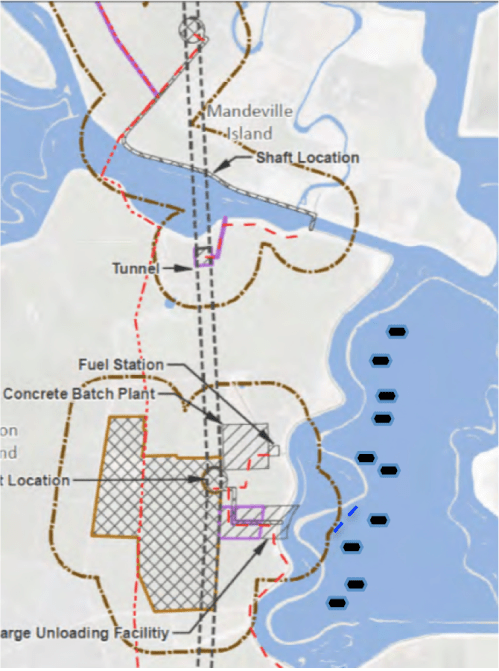
- 2024 New Tunnel Map – Eastern Alignment
- To Be Added
- 2020 Single Tunnel Maps
- Single Tunnel Map with comments about what is “New” versus what issues remain
- State provided map from the Single Tunnel Notice of Preparation (NOP)
- Same map with Jan’s annotations of boating sites within the Eastern Corridor
- Through-Delta Maps from the old WaterFix and prior BDCP project’s Through-Delta Alignment (Now called the “Central Corridor”).
- Analysis of Boating and Recreation in the Central Corridor
- Jan’s Map showing favorite Boating and Recreating waterways (South Delta)
- The Sea Ray Club’s yearly Labor Day get-together in Mildred. You can also see all of the boats that anchor out at Mildred Island on weekends
- State’s map with their plan for our favorite waterways: Construction/5 MPH zones blocking Connection Slough, Mildred/Bacon Ski Sloughs plus anchorages, blocking Middle River and all around BullFrog Marina, impacting Old River and blocking Twin Sloughs
- Close-up of the state’s plan for the Mildred Island anchorage. It looks like they are likely to wipe out the remaining levee portions that make Mildred a viable anchorage
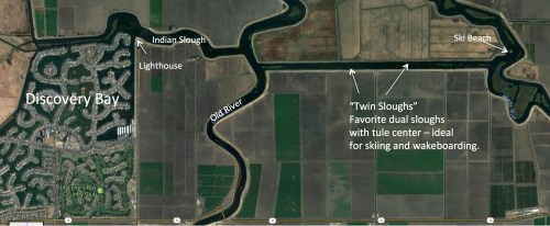
- Jan’s Map about Twin Sloughs – a favorite recreation area
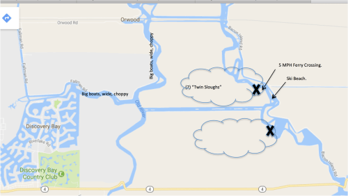
- The State’s Plan to block Twin Sloughs (they say go ski at Brannan Island instead)
- Jan’s map identifying Ski Beach – a popular weekend site. If Twin Sloughs is closed, access to Ski Beach requires a longer journey around past Union Point
- Barge Routes
- Earlier versions showed Gates that would block boating flow (those weren’t in later maps but not sure if they are in the current plan):
- Eastern Corridor
- Maps from WaterFix concerning their “Eastern Alignment”. In WaterFix, it was a canal, not a tunnel. There is no analysis of that route with a tunnel instead.
- Eastern Route – more details
- This was the route recommended by an independent reviewers. It’s further East than their Eastern Corridor, and by following the I-5 corridor it would completely avoided Delta tunnel construction impacts.
- More Jan’s Maps with detail:
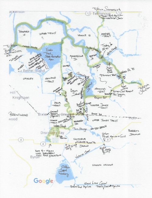
- New: Jan’s Delta Map with Islands and Marinas labeled
- Same as above with waterways important for bigger boat navigation in yellow
- Same as above with waterways important for waterskiing and wakeboarding in orange
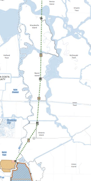
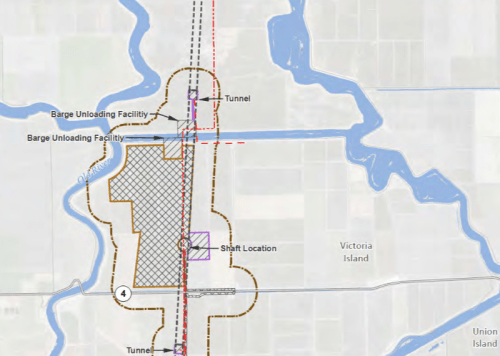
- Map identifying Bacon Island Road – the primary roadway for construction sites. The only way to get to every tunnel shaft location south of the San Joaquin.
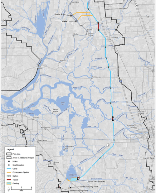
2020 Single Tunnel Map
There’s not much clarity about the two tunnel routes being considered, but we assume the gold swath (now called the “Central Corridor”) is the same as the twin tunnel WaterFix “Through-Delta Alignment” route and an alternate tunnel route the “Eastern Corridor” (purple swath), is under consideration.
New Plan with comments:


With Jan’s annotations to the new “Eastern Corridor” route here. The annotations aren’t as clear in the image below, here’s the PDF Click here.

Through-Delta Alignment (Now the “Central Corridor”)
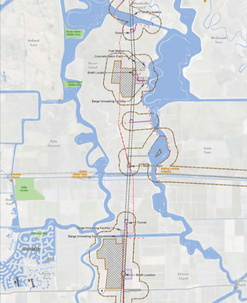
A look at impacts along the Through-Delta (Central Corridor) route:
Boating and Recreation in the Central Corridor
Jan’s Map showing favorite Boating and Recreating waterways (South Delta)
Note 1: Mildred Island and Horseshoe Bend Anchorages are never mentioned in any DWR document.
Note 2: The colored “X”s only relate to recreational waterski and wakeboarding channels. The blue Xs are the favorites ski/board channels. But others, like channels with a red X, for example, are still very important to power boats and navigation.
Further south, not shown here, is Victoria Slough – another favorite wakeboard area.
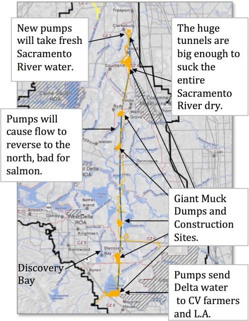
The big black crosses show where huge docks and barges will gather and construction noise from 24×7 pile driving, flood lights at night, and added electrical lines.

The Sea Ray Club’s yearly Labor Day get-together in Mildred. You can also see all of the boats that anchor out at Mildred Island on weekends:
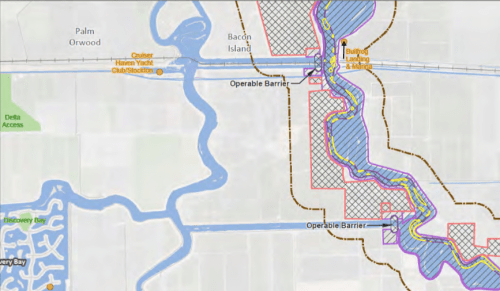
State’s map with their plan for our favorite waterways
Construction/5 MPH zones blocking Connection Slough, Mildred/Bacon Ski Sloughs plus anchorages, blocking Middle River and all around BullFrog Marina, impacting Old River and blocking Twin Sloughs:
Close-up of the state’s plan for the Mildred Island anchorage. It looks like they are likely to wipe out the remaining levee portions that make Mildred a viable anchorage. (Jan added the little boat “symbols” for anchored boats):
Jan’s Map about Twin Sloughs – a favorite recreation area:
The State’s Plan to block Twin Sloughs (they say go ski at Brannan Island instead):
Jan’s map identifying Ski Beach – a popular weekend site. If Twin Sloughs is closed, access to Ski Beach requires a longer journey around past Union Point:
Barge Routes (map from testimony provided at the Water Board permit hearings). Note that there are bridges that need to be opened for the tug boats including the BNSF Railroad bridge where opening depends on train positions and waiting would mean tugs with barges and boaters going to/from the South Delta would be milling around together – dangerous. And Highway 4 which doesn’t open now. And other bridges:

Earlier versions showed Gates that would block boating flow (those weren’t in later maps but not sure if they are in the current plan):
Eastern Corridor
Here are maps from WaterFix concerning their “Eastern Alignment.”In WaterFix, it was a canal, not a tunnel. There is no analysis of that route with a tunnel instead. So we do not know where the tunnel shafts would be, what access routes (roads, barges, rail) would be built, or where muck ponds (RTM) would be left behind.
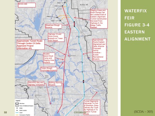
This was the route recommended by independent reviewers – the Eastern Alignment. It would have gone next to I-5, reducing both truck and barge traffic through the Delta as well as any risks from tunneling under the Delta levees. It was decided against because of cost considerations, because that route is ten miles longer.

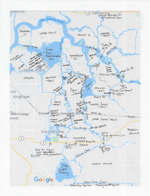
New: Jan’s Delta Map with Islands and Marinas labeled
One of my pet peeves with the State-provided tunnel maps is there is no detail. The islands, waterways, and favorite recreational sites aren’t identified. Suspicious me I assume that is intentional. I tried to copy the wonderful Hal Schell maps, but they don’t copy well and I can’t add to them. So here is my “poor mann’s version”(*) of the Hal Schell map for Delta tunnel reference. For Dawdling, not for navigation, to use Hal Schell’s disclaimer.
(*) Note pun on Karen Mann’s name and the DBYC “Poor Mann” cruise-outs.
Same as above with waterways important for bigger boat navigation in yellow
Note this clarification: The yellow west of Mildred is meant to identify the Mildred anchorages, side the levee around Mildred Island. The slough between that Mildred Island levee and Bacon Island is rarely frequented by bigger boats. That is what makes it a favorite recreation channel (see next map – favorite recreational sloughs in orange). Nothing worse than skiing, your skier drops, and some huge boat comes plowing by.
Same as above with waterways important for waterskiing and wakeboarding in orange
Note: In Discovery Bay, almost every one of the 3,000 waterfront homes has a recreational boat and/or fishing boat in the dock behind the house. In addition, at the Discovery Bay marina, there are multiple racks of boats awaiting launching. In addition, tons of recreational and fishing boats are stored in the marinas on Bethel Island. Besides these boats, people from the Northern California – from the San Francisco Bay area, Benicia, Stockton, etc. These boats travel into the South Delta to anchor at Mildred Island or visit other areas.

Map identifying Bacon Island Road
Bacon Island Road is the primary roadway for construction sites. In fact, it is the only way to get to every tunnel shaft location south of the San Joaquin. It is a little levee road requiring crossing bridges. Most worrisome is the rickety Connection Slough bridge.