(Updated 1/27/2020)
I know you are saying, “Once again? More meetings and comments?”
But this is going to be the final round! The “knock-out punch.”
And we’ve made such progress by stopping the Twin Tunnels last year. And many of our winning arguments against that plan are still valid today.
We plan to attack the Single Tunnel Plan on three prongs:
- One – The location of the Intakes in the North Bay are atrocious. They will cause blight on the legacy communities to the North. We don’t have details yet on this new plan, but the basic location hasn’t changed and is right on top of the towns of Hood, Courtland, and Clarksburg.
- Two – We fought valiantly that the Through-Tunnel Construction Project was a show-stopper. The Department of Water Resources (DWR) has now come back with two alternate routes – the old ridiculous through-tunnel route (now re-labeled the “Central Corridor.”)
(The DWR are experts at marketing/re-labeling attempts. “Muck” was re-labeled “Reusable Tunnel Material (RTM).” Doesn’t that sound nice. And the “Through-Delta Alignment” now becomes the “Central Corridor.” Not to mention the original plan was named the BDCP “Bay-Delta ‘Conservation’ Plan.” And then because the EPA said it wasn’t a “Conservation” plan, it was relabeled “WaterFix.” Sounded better than a “Tunnel Plan.”)
We proved that their Through-Delta route would cause significant impacts to boating and recreation throughout the Delta, and to Delta communities’ roads and services. The DSC Staff reported that route was inconsistent with the Delta Plan, which should have been a show-stopper. But yet it is still one of the routes being considered.
Now they are offering an “Eastern Corridor” as a “maybe” option.
This is where we need your help.
We have a great amount of detail about the impacts of the Central Corridor. You can review that information on our new Tunnel Maps page. Those maps highlight favorite South Delta boating & recreation channels and show how the Central Corridor construction plan wipes them all out.
So now we need to analyze the Eastern Corridor to see what the issues are there.
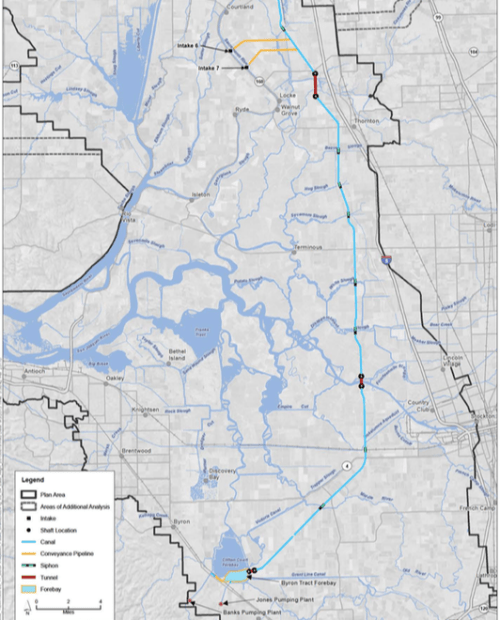
We need your help to identify if the Eastern route has issues and what they are. To that end, we have their new 2020 map and added labels for what boating sites are in the Eastern route path. Below that is their old Eastern Route which has more detail about the actual tunnel path and tunnel shaft locations. These may have changed, but it’s the best we have to-date. If you have traveled those waterways, please email me with any info you have. jmcccleery@duckpondsoftware.com.
NOTE: The map below is an image and the labels are hard to make out. For a more readable version of the map click here.
- Three – Resulting water quality. We do not believe that either alignment proposed will improve the real issues that affect the water quality which impacts the environment, the fish, and results in invasive plant species including toxic blue-green algae. We have our arguments ready there.

WaterFix Eastern Alignment. I think this map is outdated – but may help visualize where a tunnel and tunnel shafts would go.
We will be asking for your help with attending the scoping meetings (yes, sorry, we need to show up again. Thank you in advance.) The list of meetings is here: https://nodeltagates.com/event-tracker/
They think we’re tired and won’t show up again.
The best message would be for as many as possible to show up for the first meeting in Sacramento:
- Monday, February 3, 2020, 1 p.m. – 3 p.m. California Environmental Protection Agency Building, 1001 I Street, Sacramento
We’d like folks to support the communities in the North Delta that will be inundated with the intakes and pumping facilities. Those meetings are here:
- Monday, February 10, 2020, 6 p.m. – 8 p.m. Jean Harvie Community Center, 14273 River Road, Walnut Grove
- Wednesday, February 19, 2020, 6 p.m. – 8 p.m. Clarksburg Middle School Auditorium, 52870 Netherlands Road, Clarksburg
Those of you who are in San Jose or LA – here’s the meetings there:
- Wednesday, February 5, 2020, 6 p.m. – 8 p.m. Junipero Serra State Building, 320 West Fourth Street, Los Angeles
- Wednesday, February 12, 2020, 6 p.m. – 8 p.m. Santa Clara Valley Water District Board Room, 5750 Almaden Expressway, San Jose
There’s one in Stockton:
- Thursday, February 13, 2020, 6 p.m. – 8 p.m. San Joaquin Council of Governments Board Room, 555 Weber Avenue, Stockton
Show them Discovery Bay and the South Delta Communities are still committed!
We want all of our South Delta members to also attend the meeting nearest to Discovery Bay. Remember how we flooded the DSC meeting a couple of years go and they had to expand the conference room and ran out of sign-up sheets? We want to do that again:
- Thursday, February 20, 2020, 6 p.m. – 8 p.m. Brentwood Community Center Conference Room, 35 Oak Street, Brentwood
Support us and show up for as many meetings as you can. Particularly the first and last.
And we will be asking you to send in comments. We’ll send out more info about that soon.


Thank you Jan for posting the latest information. The map you obtained and posted for comments is difficult to read even after downloading given how wide they marked up the map. I still see Twin Slough and Vic slough and Middle River in the pathway of the tunnel. All of which are great places to ski and wake-board. It would be very helpful for them to provide a more detailed map and plan with where they will cross the various bodies of water, for how long, and how will marine traffic be effected during the construction.
I have two additional points from previous information you posted. The first is the actual diameter of the “Single Tunnel” which I saw estimated at 4 to 6 stories. That is a very broad range for estimating such a large diameter. A quick search on the definition of a a story has ranges of 10 to 15 feet. If you take the extreme of their numbers we could end up with a single tunnel that carries more water than the old twin tunnel design.
Finally, has anyone done an estimate of the carbon footprint of the construction of the tunnel, and made that public? If I recall it is almost 15 years of massive construction. How will the State and contractors offset the massive amount of pollution created during the construction phases of the project?
-Dave
Good points Dave. We have lots of details on the Central Corridor that I’ll repost. Did you download the PDF? There’s a link under the image for the more readable version, but it’s easily missed. I’ll update the post to make it clearer. I’ve written them requesting more details on the Eastern Route and do highlight our favorite ski and wakeboard routes. I think all are safe with the Eastern if they don’t block off Victoria. For the Central their plan is to block Twin Sloughs totally- close it off. Block the ski channels west of Mildred and make Mildred unusable as an anchorage. In fact, with the barge traffic the Central path will basically shut down Delta boating and marinas will fold.
You are correct. The new tunnel is 40-60 feet in diameter. If 60 it’s a bigger volume than 2 40 footers: more water out and more muck left.
And I agree. Air pollution is a big problem. More for the central affecting locals. The eastern does go near some marinas but hard to know the impacts without more details. We do have details for the central for years of studying it and hiring expert witnesses and its bad
Hi Jan, I did download the .pdf and my issue with reading the map is the width of the yellow and purple swaths.
As for the pollution from the construction will the State purchase CO2 offsets for the project? And if so at what cost?
-Dave
Here’s a new page with more info about impacts to boating & recreation from the through-Delta (Central) route: https://nodeltagates.com/tunnel-maps/
I just added four new maps at the bottom of the Tunnel Maps page: https://nodeltagates.com/tunnel-maps/ One has in orange the key recreational sloughs. Let me know if you agree or want others added. Is Grant Line Canal an important wakeboarding slough or more for launching and dawdling.
Regarding the width of the new corridors on the map, you are correct. The State has given us very little information to go on. We “assume” the “Central Corridor” (yellow) is the same as the old Through-Delta route. We don’t have much on the Eastern. I found an old map but don’t know if they are changing things.
I do remember discussion about pollution and purchasing offsets but don’t remember any details about it.