Riddle me this: Since the Tunnel proponents say a MAJOR justification for building the tunnels is the damage that WILL occur from the next major earthquake and the resulting RISK to water exports south, why are they planning to build their tunnels in a place and a way that ignores that same risk?
That earthquake risk is an important factor for David Sunding’s Cost/Benefits Analysis of the WaterFix (aka Delta Tunnels). The earthquake risk (or major storm causing all of the levees to crumble) is used as a scare tactic to get L.A. water rate payers to buy into the Tunnels. We heard it repeated again at the Delta Stewardship Council meeting last Friday by proponents of the Delta Tunnels: That these tunnels are needed so that when the big one, the earthquake hits, their water supply in L.A. won’t be cut off.
The claim is that when the big one hits (or a superstorm), all of the levees in the Delta will fall down, salt water will intrude, and L.A.’s fresh water exports will stop.
Although the “Earthquake Bogey” has been hotly contested time and again, it remains a key justification in the discussions.
So let’s figure this out.
The tunnel shafts being built every few miles throughout the Delta have two purposes: (a) Lowering pipe segments down to construct the pipeline during the building stage and (b) Accessing the pipeline for maintenance and repairs long-term. Continued and long-term access to these shafts is vital for the tunnel construction and long-term maintenance.

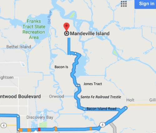
South Delta tunnel access shafts south of the channel and north of Highway 4 are on Mandeville Island, then south to Bacon Island, and Victoria Island.
In the South Delta, the shafts are all on Delta Islands.
There aren’t a lot of roads in that area. Mostly waterways.
The plan is for a 24×7 column of construction trucks to travel from Antioch to the tunnel shafts taking construction materials and construction workers and to move borrow pit dirt to build the shafts up and take muck (“Reusable Tunnel Material”) out and back to the muck pond just south of Discovery Bay.
How do all of these trucks get to those tunnel access shafts. They are on islands … surrounded by water?
There is a road (one road) that can get all of the trucks from Highway 4 to all of the construction activity on Bacon Island and Mandeville Island. One road they all need to travel on and then turn off to go to the shaft they are assigned to.
The road exits Highway 4 onto what is now a farm road, Bacon Island Road located on Jones Tract. If you recall, Jones Tract is the island that flooded in 2004 when a rodent or some other agent caused the levee to break. That was the last island rupture in the South Delta. The Sante Fe Railroad Line goes through the center of Jones Tract.
Bacon Island Road crosses the lower part of Jones Tract and then heads to the levee and runs up along the top of the levee along Jones, under the railroad trestle and continues to the Bacon Island Bridge. The trucks will cross the Bacon Island Bridge (a farm bridge that opens for boat traffic and will need to open more for barge traffic based on the busy barge plan). It travels along the Bacon Island Levee, up to perhaps the oldest bridge on the Delta, Connection Slough Bridge, across it to get to the Mandeville Island shaft.
The pictures below show these small top-of-levee roads with one side dropping off to the waterway and the subsided island farm on the other.


Small two-lane levee island roads on the tops of the levees between the waterways and Jones Tract, across Bacon Island Bridge to Bacon Island, then across Connection Slough Bridge to Mandeville.
That one and only road is on top of the very same levees that WILL FALL DOWN IN AN EARTHQUAKE (if you believe what DWR has publicized and based the need for the tunnels on). If any of the levees where the Bacon Island Road runs fail, the islands will flood and the access shafts will be totally inaccessible.
What will the cost for maintenance be when the “big one” hits? Since the tunnels aren’t being built to withstand a maximum earthquake in the Delta and are being built through soft, shifting alluvial Delta soils, there is a high probability they will crack and shift and need maintenance.
Riddle me this: If they believe their story that the Delta levees are fragile and about to all fall down, are they stupid enough to plan a project so when that happens, construction will come to a screeching halt and maintenance shafts will be in the middle of lakes and unaccessible?
This points out a glaring hole in the construction plan. They have chosen the through-Delta route for cost reasons and because they have been buying up Delta islands to avoid eminent domain problems. But they are tunneling through wetlands and areas which they predict will, in the near future, (according to them) be flooded and underwater. Where is the thinking?
Other References:
- The February 2018 WaterFix cost-benefit analysis by David Sunding discusses the risks and potential economic costs of export curtailment due to multiple levee failures from a Maximum Considered Earthquake (MCE) on the Hayward- Rogers Creek fault. Sunding’s cost-benefit analysis implies that construction of the Waterfix tunnels would result in no reduction in State Water Project and Central Valley Project exports in the event of such an earthquake.
- Yet: Tunnel experts and researchers dispute tunnel construction is sufficient in an earthquake.


0 Responses to “When the levees fall down – what’s their plan?”