Archive Page 24

Send Comments by April 17th

IMPORTANT: April 17 DEADLINE TO SUBMIT COMMENTS

The Delta Stewardship Council is working to add an amendment to include the Delta Tunnels in the Delta Plan. That is not right!

Suggested comment ideas from our Legal Council – items that are most impactful, (please rewrite in your own words) are here:
Comments Ideas/Suggestions.

EMAIL ADDRESS: Click here to send your email to deltaplanNOP@deltacouncil.ca.gov with a BCC to bdcp.commments.copy@nodeltagates.com.

Amending the Delta Plan to rubber-stamp the Twin Tunnels is just wrong, which is what we all went to Brentwood to tell them and now need to follow up with formal comments.

We also need to let them know that their process isn’t working. They could see how many people were concerned from the Brentwood meeting. But that format isn’t one where all concerns can be communicated and absorbed by the Council. We need working group sessions, and need them locally and in the evenings as well.

Most importantly, there is no valid reason for the Council to be amending the Delta Plan to accept the one alternative of the Twin Tunnels as the ONLY action. See the attachment for reasons and issues with the way the Council is moving ahead.

Please submit comments now. Thank you!

Comments Ideas/Suggestions.

Delta Locals “Flood” DSC Meeting


Mike McCleery giving feedback to the Delta Stewardship Council

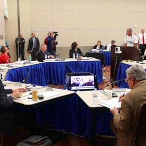
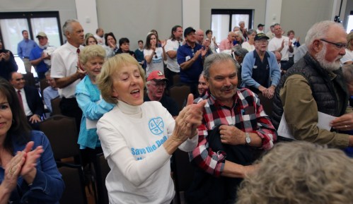
South Delta locals poured into the Delta Stewardship Council meeting on Thursday, March 23 in Brentwood. There was an amazing turnout! Particularly considering that this was the third of the DSC’s “throughout California” distributed meetings. The Tracy DSC Meeting had only 3 people in attendance; the Southern California DSC Meeting was only attended by water agency personnel.

But when the DSC dared venture into the South Delta, we showed them that the people here are 100 percent opposed to the Delta Tunnel boondoggle. There were several hundred people in attendance, many were from the Save the California Delta Alliance group and at least 70 were wearing STCDA’s new “Save the Delta / No Tunnels / No Gates” tee shirts. The DSC recognized that the crowd was there for Agenda Item 11 (obviously) and the Council moved that to be the first topic discussed.

Many people got up and made comments against the tunnels. Barbara from Restore the Delta noted problems with how the council has been holding its meetings and that the DSC meetings need better communication and format. People asked for evening meetings, when more people could be involved, and asked for more involvement in the process where their input would be considered.

Many who commented brought up boating & recreation, impacts to the water quality, the need to protect the people who live in the Delta, local farming, fish, etc. Many talked the need to improve delta flows, reduce reliance on the Delta, and reduce exports. The recent National Marine Fisheries Service report that the Delta Tunnels will destroy the fish in the Delta was brought up and quoted from. People asked why the DSC couldn’t weigh the value of almonds over the value of the Delta. Several people, questioned that the DSC is a real “Stewardship” Council and reprimanded them on the need to take their role seriously, be stewards, and protect the Delta. Bob Wright, Friends of the River legal council, made good points questioning why this amendment was being proposed at all, and stated that the tunnels should not be in the Delta Plan nor the NOP. A representative from the Sierra Club spoke and stated that the Sierra Club are with us in opposition to the tunnels. Lauren Korth, Delta Field Representative from Jim Frazier’s office read Jim’s comments which were very strong and on-target.

The DSC’s opening statement was that it is obvious the current method of exporting water is “broken,” hence a conveyance system is needed to “fix” it. Therein lies the biggest issue. If they started with the Delta Flow requirements like the legislature had directed them to do, and therefore reduced exports, then a conveyance project may not even be needed.

A few of the DSC members seemed to be swayed or impressed by what they heard. However, Randi Fiorini, the chairman, seemed to not be really listening to comments, not interested, and seemed ready to adopt the amendment and move it along. (He does come from the CV farmer side.) Although not everyone was paying attention, a couple of the council did seem to be hearing what we said. Patrick Johnston wanted to address the issue with meetings not being as effective in getting input plus the need to hold some meetings in the evening. Ken Weinberg with experience putting the Carlsbad Desalination Plant on-line appreciated the push for new desalination plants as a way to actually add water to the system. And Skip Thompson, Solano County Supervisor and representative on the Council from the Delta Protection Commission, questioned the process for amending the plan at this time and felt that the DSC seems to be trying to get around the rules. He also brought up Jeffery Michael’s Tunnel Plan Cost/Benefit analysis that showed that for every 29 cents of benefit, the cost was $1.00. Definitely not reasonable. He pushed back on the council and got a standing ovation.

Standing Ovation for Skip Thompson’s supportive remark

But then Supervisor Thompson said the DSC in their role has to make the “Grand Compromise.” I found that to be an interesting term when fish can’t really “compromise.”

Other members of the DSC weren’t as supportive of our concerns and appeared to want to just move ahead and add the tunnels to the Delta Plan.

Thanks to everyone who attended. We think some of the council members may be hearing us.

Please send any additional comments that may have come to mind by April 17th. See our Event Tracker page about the April 17th deadline to know the email address where to send your comments and see suggested comments.

ALSO – the next event is when the DSC decides whether or not to move ahead with the amendment to add the Delta Tunnels to the Delta Plan. A few council members are swaying. Help us push them over to our side by getting on the bus to Sacramento.

Town Hall a Success – Next DSC Meeting in Brentwood

THANK YOU to the 450-500 people who flooded the DB Elementary Gym to attend the STCDA Town Hall Monday night!

If you weren’t able to attend, Gene Beley is posting videos of the event. Here is Michael Brodsky’s presentation.
Gene will be posting others as he gets them edited.

And a nice write-up by Galen Kusic covering the event

We’re asking everyone to go to the upcoming Delta Stewardship Council (DSC) meeting in Brentwood. The DSC is pushing the tunnels. Show up to let them know how many of us in the South Delta oppose their tunnel plan and their threat to install salinity gates throughout the Delta.

Thursday March 23 at the Brentwood Community Center, 708 3rd Street, Brentwood, CA at 9:30 AM or meet at 9 AM in the Marina parking lot (the Boardwalk Grill parking) to carpool. The meeting starts at 9 AM but won’t get going until about 9:30 AM. We’ll be passing out talking points in a few days for those willing to stand up and make their voices heard.

Town Hall Meeting Presentations

Thanks to all of you who turned out to our STCDA Town Hall Meeting on the Delta Tunnels last night. About 500 people came out – how amazing. When Town Halls are usually held, it’s considered “big” to have 100 or more, yet Discovery Bay continues to display the passion that exists in this region against the Delta Tunnels.

Here are the presentations from last night. Let me know if you want them in the original formats instead of PDF.

Jan’s overview/introduction Presentation
Michael Brodsky’s Presentation
Diane Burgis’ Presentation

Town Hall Meeting on the Delta Tunnels Monday, March 13, 6:30 PM

Save the California Delta Alliance needs your help! Come to our Town Hall Meeting on the Delta Tunnels Monday, March 13, 6:30 PM in the Discovery Bay Elementary School Gymnasium. Hear about the progress STCDA made last year fighting the tunnels, and what’s left to do this year as the State tries to make it’s big push to get the tunnels started in 2018.

Help us stop Gov. Brown from starting his tunnel project! The eleven year construction project will wreck boating and recreation in the South Delta, removing favorite ski sloughs, blocking major boating waterways, filling our waterways with barges, docks, 5 mph zones, truck traffic on Highway 4 and the levees, 24×7 noise and lights. When done, our bays and the South Delta will become stagnant, salty, and polluted. We need your help to continue our battle. Please come to the meeting to find out how you can help stop the tunnels.

You’ll also have the opportunity to hear from your elected officials about what they are doing to try to stop the tunnels. Meet Diane Burgis, our new Contra Costa County Supervisor and hear from Jim Frazier, Assemblyman, and Senator Steve Glazer. This is the first time Sen. Glazer has come to one of our Town Hall Meetings. We’ve told him that our community is very actively opposed to the tunnels and we always have a big crowd show up. Please, let’s fill the gymnasium like we have for prior Town Hall Meetings and show them we are not giving up the fight.

Monday, March 13, 6:30 PM in the Discovery Bay Elementary School Gymnasium.

Last Day for Comments Jan. 30th

The California WaterFix (Delta Tunnel) EIR/EIS review period ends soon. If you haven’t sent in comments please do. And if you have sent in comments, but think of more to say, you can send them in multiple times. The more they hear from us the better off we will be.

Send in comments to CalWaterFix@water.ca.gov by Monday, January 30th.

And help us continue to support you! Help Us Save the Delta – Please Donate!

If you live in Discovery Bay, which will be significantly impacted through closure of our nearby waterski/wakeboard sloughs and ruining our nearby Mildred Island Anchorage, and if you are worried that the state keeps publishing atrocious plans that would block our waterways and potentially isolate us from the rest of the Delta, describe what the Delta means to you. Give your personal insight.

The tunnels are supposed to “protect and enhance unique cultural, recreational, natural resource, and agricultural values of the Delta as an evolving place.” That’s in the Delta Plan. The EIR claims that they are doing that. If you can send in comments with your own judgment that they don’t, they are violating Water Code § 85045.

If you sent in prior comments and their response to you was like many of mine it said, “Please see Master Response 24 for more information regarding the Delta as a Place.” If you, like me, couldn’t figure out what Master Response 24 was or where it was, I emailed the DWR and they sent the link:

http://baydeltaconservationplan.com/Libraries/Dynamic_Document_Library/Final_EIR-EIS_Vol_II_Part_1.sflb.ashx

But I read “Master Response 24” and it is wrong. They are saying they don’t need to protect recreation that exists for our community because they are enhancing recreation up at Brannon State Park on the Sacramento River. They are wrong. They are also saying that the Delta will evolve and they don’t need to preserve it like a Mausoleum. We are not asking them to preserve it, we know over time it evolves. Levee walls around Mildred Island get smaller, the river changes. But that doesn’t mean the State has the right to destroy our community, our economy, our culture, and our way of life!

If you live in the Delta and know what will and will not destroy our way of life, then DWR’s response, “Master Response 24” to comments that they are complying with the Delta Reform Act requirements to protect Delta as Place is flat wrong.

The more comment letters that we can get that list specifics from the EIR or at least makes the above argument, the better off we will be.

And help us continue to support you! Help Us Save the Delta – Please Donate!

The Audacity!

The State’s “Alternative” to wall off Middle River could significantly block navigation!

One of the alternatives in the Final EIR/EIS is that instead of tunnels, they would wall-off Middle River and make it their own private pipeline through the South Delta. This would block ALL boats from Discovery Bay and the rest of the Delta south of the railroad tracks from going East to Mildred Island, Bullfrog, Lost Isle, or Tiki Lagoon).

Even worse, today if the Orwood RR Bridge isn’t operable or needs maintenance, the railroad operates the alternate RR Bridge on Middle River, 24×7, year-round. But with these dams, boats too tall to fit under the railroad trestle would be blocked from getting to the alternate bridge; hence would be blocked from going to/from Discovery Bay to the rest of the Delta. That is scary, atrocious, and according to the “Rivers and Harbors Act of 1899,” illegal. Although it is not the current preferred alternative in the EIR, it is still atrocious that this idea of walling of Middle River keeps coming up in various State plans and projects.

Help us fight Governor Brown’s continual attacks against the Delta and our waterways! Help Us Save the Delta – Please Donate!


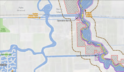
Figure 1. “Operable barriers” are actually dams that will block all boats!

In your comments to the Final EIR/EIS tell them “No Delta Gates! No Barriers!” Tell them to “Remove Alternative 9 from the California WaterFix Final EIR/EIS and never consider it again. It would violate the Rivers and Harbors act, violate the law, and violate the Delta Plan.” We still have through January 30th to comment. You can email comments as many times as you want to CalWaterFix@water.ca.gov.

To make sure the boaters aren’t ever totally blocked, the railroad was required by law to build two alternate bridges.

Boaters have always had the government’s guarantee of navigation. When building the railroad line, the railroad was required to install two identical drawbridges. The main railroad bridge is the Orwood RR Bridge on Old River. That bridge is operated 24×7 year-round. The bridge operators are always very accommodating for boaters. They apologize if they make us wait around until an Amtrak or freight train passes. We certainly don’t want a train to come roaring in when the bridge is open! It is rare to have to wait around for more than five to ten minutes, and even then the bridge operator apologizes and tries to squeeze some boats through between trains if a second train is coming along in a short while. They are very good at their job.

Figure 2. The railroad tracks and the sloughs on each side: “Railroad Sloughs”

The RR bridge needs to be able to accommodate any boat that has a command bridge and definitely sailboats. Our friends were bringing their sailboat up from Alameda to have it in Discovery Bay during the summer and anchor out with us at Mildred Island.

Figure 3. Sailboat at Mildred Island

Our friend asked the bridge operator if the bridge could accommodate a seventy-foot mast, since normally the bridge is at a slant, high enough for power boaters but not for a sailboat. The operator proudly replied, “Oh yes, captain! I can take this bridge ‘vertical’!”

Figure 4. The Orwood RR Bridge vertical after a sailboat had passed

One day there were maintenance people with orange vests crawling all over the partially-raised bridge. We were following our friends sailboat, we with our command bridge boat. Our friend radioed the bridge operator and asked him if he could open the bridge all the way for their seventy-foot mast. The operator apologized and said, “Sorry captain. We’re having maintenance done. Try to squeeze through.”

Our friend sputtered a little, not sure what to say and sure his mast wouldn’t fit under when the operator got back on the radio and laughed, “Just joshing with ya, Captain. Going’ vertical!” and opened the bridge up all the way. Whew!

But what happens if the bridge does have a mechanical failure? Well, that’s why there are sloughs on both sides of the railroad tracks (which we refer to as the Railroad Sloughs) and an identical alternate bridge on Middle River. If the Orwood RR Bridge on Old River has a failure, the operator will walk down the track and start operating the Middle River Bridge 24×7.

We are never trapped. We can always access the entire Delta. That is the law.

Our State and the water contractors seem to think they are above the law!

Although “Alternative 9 – Through Delta/Separate Corridors” is not the current “preferred” alternative, it was the through-Delta “Peripheral Canal” plan, the preferred alternative in the original BDCP Plans. It is atrocious that the state considered it originally, and that we still see it in the California WaterFix Final EIR/EIS. It needs to be removed from all future plans! The State and the Water Contractors who are writing the California WaterFix plan (i.e., the Delta Tunnels Plan) seem to think it is all right cut South Delta boaters off from the rest of the Delta! The audacity!

“Operable Barriers” are unsafe for any boat to pass through – they are the same as a dam

From researching the “Two-Gates Fish Protection Project” in 2009, where the State wanted to put gates on Old River and Connection Slough, we know these “Operable Barriers” are so unsafe boats should never get near them. They were, according to the Recreational Boaters of California (RBOC), a violation of the Rivers and Harbors Act which requires protection for navigation.

For the Two-Gates project, the RBOC stated that the only way to ensure safe passage of boats through such blockages would be the installation of actual boat locks to accommodate boats that navigate the waterway. But on the narrow sloughs like the South Railroad Slough, a lock would also be too dangerous for boats waiting for passage. Plus a barrier on Twin Sloughs would forever ruin that favorite waterski slough.

The very informative and useful comments made by the RBOC against the Two-Gates project describes in detail all of the problems with these “Operable Barriers,” how unsafe they are for boaters, and why they are actually “dams” that totally block any boat passage, large or small.

Similar gates, besides Two-Gates, have been proposed to control salinity in the past. We need to fight back at any project that shows these horrible structures in our waterways.

Help us fight Governor Brown’s continual attacks against the Delta and our waterways! Help Us Save the Delta – Please Donate!

Saving the Mildred Island Anchorage

For years, starting when our kids were 5 and 7, our family would drive from Sunnyvale to the Delta nearly every Friday night during the summer. We’d launch our ski boat at Russo’s Marina on Bethel Island and head off somewhere, find a quiet spot to anchor, put up the canvas and roll out the sleeping bags, and tie up for the night. We’d spend Saturday and Sunday on the waterways, teaching the kids to ski or pulling them behind on the “enterprise” (blow-up) or just jumping of the back swimming. Or we’d find a small beach for the kids to make mud pies and have fun. We’d barbecue at night with the sun setting behind us. The Delta has amazing sunsets.
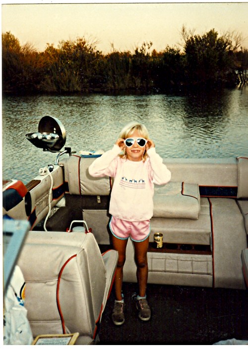

Figure 1. Boat Camping with the kids at Mildred Island in the Delta

When we upgraded to a bigger boat to camp on, we took both boats to Mildred Island on the weekends to anchor out at night and then use the ski boat during the day on the slough just west of Mildred Island waterways to ski. We fell in love with the Delta, so moved to Discovery Bay when we retired.

Mildred Island is about half way between Bethel Island and Discovery Bay, in the center of the South Delta. Mildred Island flooded in the early ’80s and was never reclaimed, making it the perfect anchorage spot. Mildred is where most boats anchor in the South Delta.


Figure 2. Mildred and other Anchorages near Bethel Island and Discovery Bay

Having a nice anchorage near by is one of the draws for buying a home in Discovery Bay. Being close to fishing, ski/waterski sloughs, and an anchorage is why Bethel Island has over 30 marinas all the way around the island. Most boats come from the near surrounding areas (Bethel Island, Byron, Oakley, and Discovery Bay) but others come from San Francisco, Benicia, Stockton, etc.

Mildred is a well-known anchorage. On Labor Day, the Sea Ray Club brings about 60 boats and form a complete, perfect circle: quite an engineering feat. The Grand Banks Club, Bayliner Club, Discovery Bay Yacht Club as well as other groups and clubs use the Mildred Island anchorage regularly. In addition, numerous small groups and single boats anchor at Mildred Island for a weekend, a week, or more. No other South Delta location can provide an anchorage for so many boats.
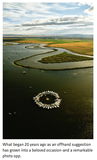

Figure 3. Sea Ray Club “Full Circle” at Mildred Every Year (From Sea Ray Club Website)

The only other anchor area for more than a handful of boats in the South Delta is what the locals call Horseshoe Bend, west of the Connection Slough Bridge (see Figure 2 above). Horseshoe Bend can support perhaps up to 20 boats.

Besides these two anchorages, there are only a few sloughs in the South Delta where one or several boats can slip in behind some tules and anchor for the night or weekend, but no other anchorage.

What plans does the State have to protect the Mildred Island Anchorage?


ANSWER: None. Just the opposite. The State will make Mildred unusable as an anchorage and hard to get to for eleven (yes 11) years.


Figure 3. Construction at Mildred Island and Connection Slough

As you can see in Figure 3, the State plans to build a huge dock and have barges, construction, 24×7 pounding and bright lights from June 1 to October 31 each year (i.e., all summer months) for eleven years right next to the Mildred Island Anchorage. It certainly won’t be a peaceful anchorage any longer. It looks like they may even wipe out the levee where the doggie beach is. They will leave behind a giant, smelly muck pile, just west of a peaceful pristine anchorage. Unbelievable!

They will also put a dock and barges in Connection Slough. There they say they will try to allow traffic (5 MPH), but I do not trust them to do a reasonable job of notifying the public ahead of time of closures and delays.

Their plans show other brown areas, construction of some sort, potentially blocking the way to Mildred Island from the South. Again, I do not trust them to do a reasonable job of notifying the public ahead of time of closures and delays and not blocking boats from getting to or returning from Mildred Island.

Implications for Recreation (Skiing/WakeBoarding)

Besides making it difficult to get to Mildred from Connection Slough, the State will also be wiping out recreational boating (skiing and wakeboarding) along the western side of Mildred Island. That is the second favorite ski site after Twin Sloughs. While there are also nice sloughs on the south side and east side of Mildred, during busy weekends those are the sloughs the big formula boats and big cruisers take. Especially during a big can poker run, skiing or wakeboarding those sloughs is not advised

What can we do?


Send in your comments before January 30th that our town doesn’t want the State to wipe out the main anchorage for the South Delta. Yet this is the State’s plan in its Final EIR/EIS on the California WaterFix.

Even after people identified Mildred Island as the important primary anchorage for the entire South Delta in comments in 2013 and 2016, and in person at BDCP meetings, the Final EIR still failed to include Mildred Island as one of the key Recreation Sites in the South Delta or to refer to it at all.

Table 15-15 that lists important Recreational Sites throughout the Delta does not include Mildred Island nor Horseshoe Bend. Both should have been included and discussed in the analysis, primarily a discussion about what is the value of keeping boats in the Bethel Island marinas or the value of boating from Discovery Bay.

The EIR also fails to adequately identify the actual boating need. There are probably 4,000 boat berths in Discovery Bay counting private docks and the Marina. Yet the EIR only analyzes marinas and doesn’t count boats per marina. The analysis of where boats are and where they go is missing from the EIR.

The Final EIR Chapter 15 – Recreation, fails to adequately analyze activity in the Delta. As a result it does not consider the economic impacts or safety implications for the South Delta communities and boaters: Discovery Bay, Bethel Island, Bullfrog Marina and other marinas where these boaters who come to Mildred Island go for supplies, fuel, or other shopping. (Anchored boats typically have another small boat, ski boat, or tender where they can get fuel and supplies during their anchor-out).

The analysis in the EIR is inadequate, incomplete, and flawed.

STCDA is still working to fight for the rights of the Delta communities as well as the fish. An alternative Rep. Garamendi and others have proposed is a portfolio of solutions, with one component being a single, smaller 3,000 CFS pipe. Even if the proposal for a smaller, less damaging pipe is accepted, there will still be a tunnel along the same alignment, causing perhaps shorter-term impact, but still ruining our waterways and the Mildred Island Anchorage.

There are alternatives regardless of what size pipe they decide to run:

  1. Pick their Eastern Alignment Alternative. Instead of going through the Delta, the only way to save it is to go around the Delta.
  2. A the least:
    • Move the barge location away from the Mildred Island Anchorage. Metropolitan Water District owns the entire Bacon Island. If moved south where the road/overpass is and construction activity were kept isolated to the western channel, boat traffic could still pass on the east, under the Bacon Island Bridge.
    • Maximize accessibility to/from Mildred Island from Bethel Island and approaching from the south on Middle River.
    • Locate the muck pile as far south on Bacon Island as possible.
  3. If not the entire Eastern Alignment, at least reroute as far east as possible around Mildred Island and the waterways south of it. That would leave boating open in the South Delta as well as not impacting fish and fowl.

Boating communities deserve at least some commitment from the State to try to maintain navigable, usable, scenic waterways and minimize impact from their tunnel construction destruction.

Send in your Comments


Email your comments/objections to this plan to: CalWaterFix@water.ca.gov. Note: This link also adds a BCC to our mailbox for reference. In 2013 it took them THREE YEARS to post people’s comments!
Do you ski/wakeboard the Twin Sloughs?

Are you a Discovery Bay boater? Do you or your kids like to take the ski boat or wakeboard boat out for a quick run: before work, after school, or on weekends? If so, you may want to read what the state is planning to do as early as 2018!

Where do you go skiing or wakeboarding? Say you are making a quick run. You head out past the lighthouse a ways (especially on weekends, far enough so the formula boats and big boats aren’t rocking your start) and put a skier/wakeboarder in the water. We head east on Indian Slough to Old River, turn right and ski from there. South on Old River is the safer ski-water: less big boats and calmer water. All the go-fast formula boats and big cruisers turn left on Old River to go through the Orwood RR Bridge and beyond.

You can ski south on Old River to where you have to make a U-turn because of the Hwy 4 bridge. But even better, as we go by Twin Sloughs, we glance and if there aren’t a lot of boats, we head east up the right side of Twin Sloughs. That’s our favorite nearby ski slough.


Figure 1. Satellite view of the Twin Sloughs

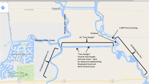
Officially, what we locals call “Twin Sloughs,” are named “North Victoria Canal” on the right (south) and “Woodward Canal” on the left (north), named after the islands they run next to. They used to be two separate canals, but over time the levee in the middle eroded and now there are even places where where a boat can get through. What is left of the old levee divides the two sloughs into separate lanes. Everyone knows to stay on the right, U-turn at the end, and come back on the other side. That’s one of the great things about the Twin Sloughs. They are safer because, like a divided highway, traffic is managed. The other reason the Twin Sloughs is so popular is because they are each just the right size for a skier to slalom or wakeboarder to make his/her curves. And the tules on each side and down the middle dampen boat wakes so that the water quickly settles down and each skier gets their turn on glassy water.

We often go up and down Twin Sloughs until our gang gets tired. If Twin Sloughs is too crowded, there’s the option to ski Middle River. North on Middle River is just a short run past Ski Beach and you need to turn around before the 5 MPH zone at the ferry crossing. South on Middle River towards Union Point Bar & Grill is descent until you need to turn around because of the 5 MPH zone and Hwy 4 bridge.

That’s our “typical” ski run from our home with our kids, grandkids, or when friends go out in the morning or during the day. Here are the ski/wakeboard runs accessible nearest Discovery Bay and what makes our location so convenient:

Figure 2. Discovery Bay Recreation Sloughs

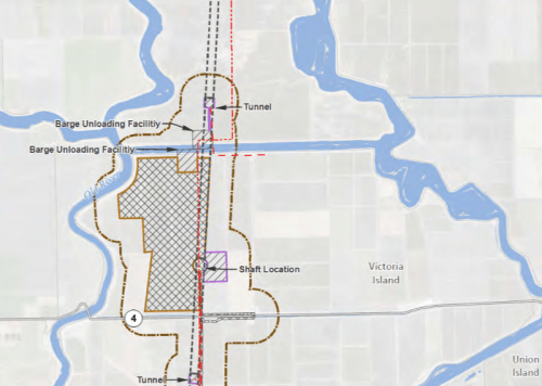
And here is what the State plans to do to them:


Figure 3. DWR Official map of Construction areas: Barges, docks, ruin – for 11 years!

Twin Sloughs will be completely blocked during the summer for eleven (yes 11) years because there will be two docks built there: one on Woodward Island on the north side of the twin sloughs and one on Victoria Island to the south. The impact area shows that even access to Old River going south will be closed some of the time with barges and construction blockages. I believe the brown outline identifies areas that will be 5 MPH zones at best.

That means no access to Ski Beach either. And you won’t be able to jet ski the short route over to Union Point Bar & Grill.

Small recreation boats leaving DB to go skiing or wakeboarding will have only a small run near DB or will need to check out the traffic going north on Old River and east on Railroad slough to get to the nicer calm areas west of Mildred Island.

My crowd (I guess we’re spoiled) choose to not ski up Old River and Railroad slough and instead take a boat ride until we get past the Bacon Island overpass to the sloughs west of Mildred that is our other nice, calm, glassy-water ski/wakeboard area. Oh, but wait until you see what the plans are for Middle River and Mildred Island! (You’ll need to wait for the next blog.)

The State surely wouldn’t ignore the value of boating and recreation to the community of Discovery Bay, would they? What is their mitigation for the people of Discovery Bay?

Their “mitigation plan,” because they are wiping out Twin Sloughs, is that there are other similar sloughs in the Delta. Specifically, they say we can go ski at Brannan Island. What? Just do a quick ski run to the north side of the San Joaquin and to the Sacramento River? Getting there isn’t something we can do for a ski boat run. Obviously, people working on projects for the Delta have no clue about the Delta.

What can we do?


Send in your comments before January 30th that our town doesn’t want the State to wipe out our recreation sloughs. Yet this is the State’s plan in it’s Final EIR/EIS on the California WaterFix.

If your teenage son/daughter likes to wakeboard, this would be a great lesson in civic duty to send an email to let the State government know just what they think about the State’s plan for Discovery Bay waterways.

The Final EIR that we’re commenting about during this timeframe doesn’t even list boating and recreation as important for Discovery Bay’s economy or community! The analysis in the EIR is inadequate, incomplete, and flawed. Discovery Bay isn’t even mentioned, even though if you look through previously submitted comments in 2013 and 2016, more than once Twin Sloughs is mentioned as a recreation area to maintain, and that boating and recreation is key to Discovery Bay’s economy and community. The EIR Chapter 15 – Recreation doesn’t even list Discovery Bay as a boating site! The only reference to Discovery Bay is as one of the communities in Contra Costa County. There is nothing about the 2,300 waterfront homes in Discovery Bay that each have boat slips (most have even more than one). There is nothing that identifies that recreational boaters need continuous sloughs where they can go up to 30 MPH, not barges all over to go 5 MPH around. Tell them you object!

STCDA is still working to fight for the rights of the Delta communities as well as the fish. An alternative Rep. Garamendi and others have proposed is a portfolio of solutions, with one component being a single, smaller 3,000 CFS pipe. Even if this proposal goes through, it will still be a tunnel along the same alignment, causing perhaps shorter-term impact, but still ruining our waterways and leaving Twin Sloughs forever ruined.

There are simple alternatives that would save recreation near Discovery Bay regardless of what size pipe they decide to run:

  1. THE BEST – Use the Eastern Alignment Alternative. This would be best for boaters, fish, waterfowl, and the Delta. I don’t know who that route effects, but no towns or communities. There is nothing in the EIR “Alternatives Considered” documentation that I can find that considers the impact on people related to their considered alternatives.
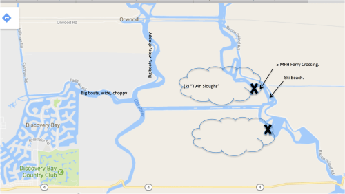
  2. AT A MINIMUM, move the barge locations around the corner on each island. That can’t be so hard and saves a lot of boaters a lot of grief. Saving nearby recreation will help our community remain a viable boating community.


Figure 4. Alternative Barge Locations

Send in your Comments


Email your comments/objections to this plan to: CalWaterFix@water.ca.gov. Note: This link also adds a BCC to our mailbox for reference. In 2013 it took them THREE YEARS to post people’s comments!

Your Comments Needed!

We are in the midst of another very short comment response period on the Delta Tunnels due January 27th. The Final California WaterFix EIR (what used to be the “BDCP” and is now just the Delta Tunnel part) was released end of December with just a 30-day comment period. I’d appreciate if people would email requests to extend the comment period to at least 90 days. Also posted in December was responses to all of our comments we sent in during the 2013 comment review period AND the 2015 comment review period. They waited 3 years to post our 2013 comments and now give us 30 days to review! (Actually, less because it’s taken some time to even find out they were there). And to review the huge final EIR.

Please send in an email asking to extend the comment period to at least 90 days here: CalWaterFix@water.ca.gov.

Note: This will also send a BCC copy to us for reference, since in 2013 it took them THREE YEARS to post any comments! We’d appreciate that.

If you have time, also send in your comments on the new BDCP EIR Final which is posted here (in case we can’t get the review period extended):
FINAL EIR/EIS Click Here

To see what their response was to the comments you mailed in over the past years, go here:
RESPONSES TO YOUR PRIOR 2013/2015 COMMENTS Click Here

HOW TO FIND YOUR COMMENT AND THEIR RESPONSE:
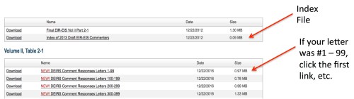
There is an “Index” file for the 2013 comments and down further in the page an Index file for the 2015 comments. Look at each index file, find your name, and there will be a “Letter #” next to your name. Below the index file is a list of comments broken up by letter #s. Click the link where your letter # falls and find your comment in that list with the response next to it. See instructions/screen shot at the bottom (attachment). They don’t make it easy on us!

Here are a few good reasons to extend the comment period and hold a public hearing:

1) They failed to recirculate the Draft EIR/S after it received a failing grade from USEPA. Under the law they are required to fix the problems and recirculate a draft EIR for further public comment when that happens. So they are using this final 30 day comment period to substitute for that required recirculation which should have been a long time ago and allowed for a much longer comment period. Because of this they should allow at least 90 days and hold a public hearing now.

2) They failed to adequately respond to comments.

3) They failed to consider an adequate range of alternatives because they did not consider any alternative with a storage element or any other portfolio element.

4) They failed to comply with the Delta Reform Act because the preferred alternative does not reduce reliance on the Delta.

These are all major substantive failures and 30 days is not enough time to adequately address these issues in comments so we need at least 90 days to prepare comments so the comment period should be extended.

Item #2 above would be even better if you add one of your comments and their response that didn’t answer you adequately.

THANK YOU!


Blog Stats

  • 130,140 hits

Support the STCDA

Sign up for Emails

Sign Up Now

Request a New Lawn Sign

Click Here to send an email to the lawn sign committee.

Receive news blog via email.

More Blogs

Educational Books about the Delta

Sassy the Salmon
and
The Fable of the Farmer and the Fish
All ages: K and above
Proceeds go to STCDA