Clarifications added 5/14/18: At the Water Board Hearings April 20 and 23, the Save the California Delta Alliance experts testified about the impact of the tunnel construction project on the waterways, roads, and communities due to barge traffic, in-water construction, high volume truck traffic on small Delta roads, and noise pollution.
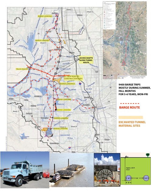
Suffice it to say, the Delta waterways will be virtually unusable for boat traffic during the years and years of construction. In the map below, red dashes show the barges – over 9,000 barge trips over 5.5 years. Other documents state construction will be ongoing for 11 years.
Even though they will be boring a tunnel, 150 feet down, there are access shafts to the surface every few miles. At those shafts, there will be construction and noise, pile driving, big docks built for barge loading/unloading, trucks on the levee walls to take the tunnel liners off the barges and conveyer belts to put tunnel much on the barges. This activity will be noisy, dusty, 24×7 during boating months so flood lights at night. New electric transmission lines will be run down the route (ruining views of Mt. Diablo). The shaft sites will be built up 25-35 feet above sea level.
As you can see from the dashed redlines, barges will be traveling from the three staging areas (Antioch, Bouldin Island, and Clifton Court Forebay) to each of the access shaft areas.
Note that the barge route to/from Clifton Court Forebay goes under Highway 4, requiring the first bridge east of Discovery Bay to be opened multiple times/day. I’ve never seen it open. Frank Morgan, operator of the Rosemary, has been out in his boat for 30 years and only saw it opened once. He called to get it opened on day but was told it wasn’t operable. Now, picture the commute traffic from Brentwood/Discovery Bay to Stockton. Currently it is heavy commute traffic and very dangerous due to the two-lane levee road with no shoulders, sloughs on either side, and extremely narrow bridges. Now let’s open that bridge for at least 20 minutes to get a barge through, multiple times per day. Now let’s include in the traffic line-up a long line of construction trucks trying to go from Antioch through the bridge and left turn on Bacon Island Road to get up to those sites. This is nuts. And it repeats throughout the Delta’s on the small, narrow highways.
As Bill Wells testified talking about the Bouldin Island site, “There is no hydrological rationale or engineering necessity for picking this location. It happened to be convenient for DWR and our legacy communities, absurdly dwarfed by the adjacent massive construction works, must be destroyed as a result. They have insisted on locating their largest staging facility and muck dump on Bouldin Island, off of Highway 12, between two drawbridges that will be prone open by constant construction barge traffic—creating the worst traffic nightmare imaginable on the main recreational gateway to the Delta. (SCDA-104.) There is no reason why this facility has to be located here.”
Bottom line, access in and out of the Delta to get to marinas and other launch sites will be nearly impossible. If you can get here and launch your boat, your travels throughout the waterways will be anything but peaceful and relaxing. The sloughs will have multiple 5 MPH zones around barges and landing docks – not conducive to water skiing or wake boarding.
How can the Delta still be a boating and recreational hub with this construction project going on, from north to south?
Santa Clara Water District is voting Tuesday May 8 on whether or not to support the tunnels. Having the Delta so close to Silicon Valley was a big draw in our decision to work there and water ski/boat on the weekends. If they vote yes for the tunnels, they will be taking a prime recreational area away from the constituents!
In the next blog, I’ll write about an alternative route that would avoid all of this mess – the Eastern Alignment.


0 Responses to “What we Found Out about Construction”