CA Department of Fish & Wildlife (CDFW), being paid by Metropolitan Water District (MWD), recently completed a report called the “Franks Tract Feasibility Study.” It is a plan to fill in half of the Franks Tract State Recreation Area to create Delta Smelt habitat plus build a salinity wall to keep salt water from getting to the export pumps at Clifton Court Forebay.
I found that the report has significant flaws.
The problem with the report is it picks the wrong place for a Delta Smelt habitat project. There are other islands nearby just as viable and already owned by MWD.
Did I mention that Franks Tract is the primary bass fishing area in the state (or some say, the nation) and the plan calls to reduce bass habitat (i.e., get rid of the bass)? Since bass fishing is a big deal to the economy of Bethel Island and much of Northern California, getting rid of the bass is not a really good idea. Particularly when the CDFW’s own Deputy Director says the department’s position is that predation (by bass) isn’t the main cause of fish decline.
And while the proposed salinity barrier may help the exporters, it makes things worse in other areas of the Delta.
Here are the details.
1 – About the Delta Smelt
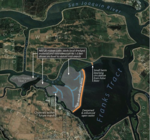
You know me. I love the environment. But why destroy Franks Tract, a State Recreation Area prized for bass fishing, hunting, and boating? And while they’re at it, destroy the economy of Bethel Island by walling off marinas (Russo’s and Bethel Harbor) and other businesses (like the Rusty Porthole and the Sugar Barge) from access directly in from Franks Tract. There are weekly bass fishing tournaments going out from one of those places, which are a huge part of Bethel Island’s economy.
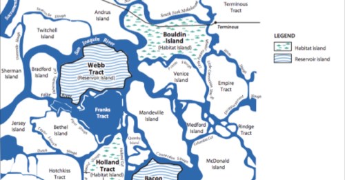
Why Franks Tract? First, there are islands nearby, owned by MWD, some planned already as habitat, which could have been the focus of the study instead of Franks Tract, which is so important for local economies. MWD owns Webb, Bouldin, Holland, and Bacon Island. Where is the analysis of why Franks Tract was chosen?
They say it is one of the less subsided islands so requires less fill dirt (which is expensive, I guess).

While Franks Tract is less subsided than some other islands, the west side of Webb has an area the size of the proposed tidal marsh which has both green and yellow (i.e., nearly as shallow); and the west side of Holland is 0-2.5 m. same as Franks. MWD owns both of those already so altering them would not impact communities or Delta activities.
Before destroying local communities, other alternatives that can satisfy the same objections need to be reviewed. But they weren’t.
Why Franks Tract? The choice is claimed in the report due to two paper by Grossman which called out “hot spots” where Delta Smelt face predation. First, in that report, Grossman lists 13 “hot spots” (like the HORB) and most of them are where dams or other blockages occurs, trapping the smelt and making them easy prey. So if dams are a problem, why put a dam down the middle of Franks Tract and create more areas for predation? Using Grossman’s papers as justification for focusing narrowly on Franks Tract is not valid.
Expanded, the first goal is stated as: “create habitat suitable for Delta Smelt.” and objectives are, “Key restoration objectives include reducing the extent of aquatic weeds, decrease predation on Delta Smelt and other native fishes by lowering habitat suitability for non-native species, and improve food webs.” But, are those the right objectives? The goal to “decrease predation on Delta Smelt and other native fishes by lowering habitat suitability for non-native species, and improve food webs” must be challenged.
Predation is not the major issue for Delta Smelt. Lack of fresh water flow is.
The objective of lowering habitat suitability for non-native species means bass. And bass fishing is a core component of the Delta and needs to be supported and preserved.
The theory (that the bass, which were introduced in the 1870s, are suddenly to blame for the salmon and other native species’ demise) is hotly contested among scientists and should not be used as a primary reason to destroy the economy of the Delta by destroying the primary bass fishery, Franks Tract.
According to a 2016 Sacramento Bee article, CDFW’s own Deputy Director disagrees. The article states that:
Their [the State Agencies exporting water] concern is less about the fish and more about how the population declines affect their water supply and livelihoods. Court rulings empower the federal fisheries agencies that monitor species to govern water flows in the Delta, and their decisions often translate into pumping limits to keep fish from being harmed.
There’s too little known right now,” said Stafford Lehr, deputy director of the Wildlife and Fisheries Division of CDFW. “The consensus of the research is there’s more going on (with native fish declines) than predation. That’s the department’s position.”
Peter Moyle, a veteran fisheries scientist at UC Davis, is among the researchers who say striped bass are unfairly blamed for the declines in native fish. He described the striper as a “scapefish,” whose numbers have suffered marked declines in recent decades, alongside native fish. The real issue, he said, is what humans have done to the environment by over-allocating water to competing interests.
Scapefishing the bass has been going on since the bass fishermen testified to the Legislature against the exporters and made them a target. It’s like in my childrens’ book, “The Fable of the Farmer and the Fish.” The exporters want to find any excuse for why the fisheries are failing, except the obvious – too much water being exported.
In my opinion, their justification of Franks Tract as a location for a tidal marsh doesn’t hold water. Their research is lacking and better options are available.
So what about the second goal?
2 – Salinity Control
A year ago the State installed a rock dam in False River. That caused numerous issues and is a costly “emergency effort.” It wouldn’t have been needed if the State would balance the need every expanding almond orchards against available water and simply reduced exports. But alas, I repeat myself.
This project is supposed to be a long term fix for salinity coming into the Central Delta and Clifton Court Forebay.
Here’s their modeling about how their wall down the middle of Franks Tract will improve salinity control.

You can watch the simulation live at these links:
They are kind of mesmerizing to watch.
But their project causes salinity problems
What strikes me from the simulation, is that with the project, the salinity is always worse along the San Joaquin River and goes further inland. How will that affect the farmers that draw water up the San Joaquin towards Rio Vista? The write-up agrees that, “It potentially increases salinity on the main stem of the San Joaquin River between Jersey Point and San Andreas Landing.” Has the effect on farmers along the San Joaquin been studied?
Today, Bradford Island has access to fresh water during an outgoing tide as does Webb and Bouldin. With the “restoration” project, Bradford Island would be surrounded always with saltier water. That island is now used to raise cattle. The fresh water is needed to grow their feed and water them. What is the plan to compensate the Bradford Island owners?
Is this really better?
Well, here’s the answer:

With the project, the water quality at Clifton Court Forebay (where exports occur) improves. But, water quality will deteriorate along Middle River including Mildred Island. Since those are key water recreational areas, that is highly undesirable. Those are areas where humans swim and recreate. The impact on health needs to be included in this survey.
The goal shouldn’t be just to improve water quality for users south, it needs to include improved water quality for the in-Delta users.
Once again, our state agencies trade off health and safety for citizens in the Delta in order to facilitate exports for the southern users.
Piper Slough: The report says they need to do more modeling about the flows along Piper Slough. (That is the slough that goes next to Bethel Island, where all the marinas and home docks are). They claim the project wouldn’t increase flows “much” but how do you funnel all of the water from False River and Fisherman’s Cut down the small narrow Piper Slough, with the entire Franks Tract dammed, without causing a rush of water flow? It doesn’t make sense to me. I am worried about the boating safety, wear and tear on docks, etc.
Fisherman’s Cut: I am also concerned about the increased flow through Fisherman’s Cut. The report said it will not be as bad as when the False River Dam was installed, but that flow was totally unacceptable and created scouring concerns at the “Horseshoe” area of Bethel Island’s levees. This deserves more attention, including impact on the people with homes and docks along Fisherman’s Cut.
What does it mean to take local concerns into account?
The report talks about how local concerns were incorporated. It recognizes that, “Most [it should have said “ALL”] stakeholders strongly objected to the location and configuration of the proposed tidal marsh restoration areas in Franks and Little Franks Tract because it would block some marina and boat traffic to residential areas.” [That isn’t even worded logically – it blocks businesses AND residential docks.]
The report lists the negative impacts in sidebars, in sections. Yet the project continues ahead with the original proposal. I guess that is what it means when State Agencies say they are communicating and listening to those people affected. It means the list the concerns, nod, then move ahead.
This project is totally unacceptable. Alternatives that do not affect Franks Tract must be evaluated.


We should tie the twin tunnel proposal to High Speed Rail program. The parallels are hard to ignore, and the connection can make the tunnels clearer to understand.