ADDED 1/24/2018: Take the Franks Tract Survey.
I was invited to attend a meeting at the San Joaquin Yacht Club last week about a new “Franks Tract Feasibility Study.” There were many Bethel Islanders representing marina owners, restaurant owners, realtors, Bethel Island Municipal Improvement District (BIMID) representatives, Bradford Island landowners, and others. It was a good turn-out.
The presentation was by Carl Wilcox, California Department of Fish & Wildlife (CDFW). He was accompanied by two UC Davis researchers working on the project: Brett Milligan and Alejo Kraus-Polk. Their role includes gathering community feedback.
It was nice that this project is working to obtain information from the affected groups early in the process. This is the study phase. Apparently it started earlier in 2017. The Study Report is due March or April this year. $400K has been spent on the Study to-date.
Here’s the plan (the figure on the right). It shows a tidal barrier down the middle of Franks Tract and filling the west side of Franks Tract and Little Franks Tract with fill dirt to make it tidal marsh at high tide, dirt at low tide. They would add a dam on False River midway (top right on their figure). This would be instead of a dam on the west side of False River where it joins the San Joaquin which was done a few years ago. There were numerous problems with that dam.
Note: That dam means, like when the prior False River Dam was installed, boats from Discovery Bay and elsewhere South/West would not be able to use the route north of Franks Tract via False River to the San Joaquin Channel to go to Pittsburg, Benicia, or San Francisco but instead would have to go the long way straight up to the Channel via Old River and follow the Channel out.


The drawing on the left is my “creation” to try to show the size of the fill versus Franks Tract as it is now.
The project write-up is:
-
The California Department of Fish and Wildlife (CDFW) is working on a feasibility study for a project that would fill certain portions of Frank and Little Franks Tract to create tidal wetlands and control salinity intrusion into the inner Delta. Modifications would occur on the western side of Franks Tract, above Piper slough and between Bethel Island and Webb Tract, and in the confluence of False River and Fishermen’s cut. Much of this area is currently dominated by shallow water and snags, and is a known boating hazard.
Preliminary biological objectives for the project include enhancing habitat for Delta Smelt and other (native) fish species, minimizing habitat for invasive plant species, and the establishment of 1000 acres of tidal marsh and tidal sloughs. Preliminary physical objectives include changing tidal circulation to more closely resemble historic conditions, eliminating tidal flow and limiting salinity movement through Franks into Old River, and enhancing turbidity and residence time in False River and areas west of Franks. Navigability through Fishermen’s cut, False River, and Piper slough will not be affected, however, hydrodynamic modeling predicts increased tidal action in Fishermen’s cut although not to the extent seen with the emergency drought barrier. This proposed project differs from previous projects in its attention to the concerns of boaters and the Bethel Island community.
If this concerns you, here’s a survey they would like boaters and fishermen who go to Franks Tract to fill out: Franks Tract Survey.
Issues are that it would block boating from the South/East Delta through False River and out, and through Franks Tract to Bethel Island marinas and restaurants. Boats wanting to go to Rusty Porthole for dinner, Sugar Barge, Russo’s, Piper Point (the old Bethel Harbor), plus all of the homeowners and others would need to travel all the way via the 5 MPH Piper Slough.
Naturally, the plan raised lots of consternation from Bethel Island folks. Every weekend Bethel Island holds bass fishing tournaments, bringing in an average of $200K per event. The fishermen come directly in to the event (typically held at Sugar Barge or Russo’s) directly from Frank’s Tract (fast water) through one of the breaks in the levee outside those establishments. Asking fast fishing boats to take the very long way up Piper Slough would definitely cause the events to be held elsewhere. It would impact if not close business at Rusty Porthole, home of the January 1st Frozen Bun Run. You can’t have a Frozen Bun Run ski tournament if you have to first toodle down 20-30 minutes of 5 MPH zone to get to fast water.
The majority of boats the visit Bethel Island cut across Franks Tract. With this project, that would be closed off, losing their participation in Delta-wide events like Big Cat Poker runs and the like.
And what about bass fishing? Bethel Island is renown, not just in the Delta but throughout the U.S., as the top bass fishing area in the country. Striped bass and black bass events are huge. Bass also contributes significantly to the economy of Northern California – think of all the bass fishing boats we see zipping around continually. Boat sales, equipment, clothing, etc. are a big industry, as I found out at the Simm’s Bass Fishing event at Sugar Barge late last year. The bass fishermen say this project would basically kill bass fishing.
Carl Wilcox and his team had also met with the West Delta Chapter of the California Striped Bass Association December 15th and Roger Mammon reported that “We were unanimous in that it would destroy one of the best Striped Bass fishing areas in the Delta as well as the world class black bass fishery. We concluded this meeting expressing our doubts about this project due to all the potential negative impacts for our Delta and the East County economy.”
While it was nice that CDFG is trying to get local feedback, it did feel like other State projects where they collect comments and feedback but then those don’t influence the project significantly (aka the “WaterFix” or Delta Tunnel plan).
The “Franks Tract Feasibility Study” has two stated goals: Block salinity intrusion and improve habitat for Delta Smelt. Are either of these goals truly to improve the Delta? The real answer would be “No.” The project would ruin the community of Bethel Island economically and destroy the largest bass fishing area in Northern California. After all, Franks Tract has been named a “State Recreational Area.” (Attendees asked why a representative from Parks and Recreation wasn’t in attendance).
The Bethel Island attendees asked Wilcox why the focusing on Delta Smelt and he answered truthfully, because the smelt were the reason for environmentalists to keep shutting down the pumps. The other purpose, to stop salinity intrusion, is also because they plan to continue to over-export and allow salt water to intrude beyond the point the State committed to, the X2 line near Pittsburg. Franks Tract is way further inland than Pittsburg.
The obvious take-away is that we have the State working on yet another project, not due to concerns about the Delta as an ecosystem but with the sole purpose of allowing the exporters to continue to export water from the Delta at the current high levels or higher.
In addition, we noticed that the project will require a large amount of fill. Suspiciously, we think, “Hummmm – the State is getting pushback on not having a plan for where to dump tunnel muck,” (which they renamed “Reusable Tunnel Material,” but muck by any other name is still muck). How much of this project is being pushed forward to solve a big part of that problem? Having worked with State agencies for years and watching them push for the Delta tunnels, and knowing they currently have a problem with permits because they don’t have sufficient plans in place for how they will dispose of the tunnel muck and at what cost, having 1,000 acres to dump 5-10 feet high with tunnel muck would significantly help them out.
An alternative proposal was offered by Bethel Island resident David Gloski, who holds an undergraduate engineering degree from MIT and a masters degree. His proposal is a true compromise, that would meet their stated goals of salinity barrier and smelt habitat but would not do as much harm to their community, to the bass fishing industry, and would actually improve boating and access. A real win-win.
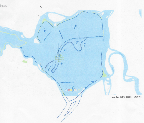
The alternate creates three tidal marshes, “A”, “B”, and “C”. There are areas that are already somewhat filled with vegetation and not fished as extensively. Then a tidal wall would be constructed in the middle as shown with an optional additional extension “V” if needed. “W” is the existing island which could be built out and improved for access and recreational use. “X”, “W”, and “Z” indicate beach areas and anchor buoys. The proposal includes dredging on the west side to improve boating access through Franks Tract and reduce the number of snags and boat issues. It would also create a new anchorage; a much-needed South Delta recreational area, since Horseshoe Bend south of Bethel Island has issues with snags getting in/out of it which leaves Mildred as the only South Delta anchorage. Mildred is losing its beaches (I’d love to see the State add more beaches there), but this proposal would be a good option! This proposal still leaves fast water access available to the marinas and restaurants.
Wilcox declined to commit to adding it to their study. He only said he would “see . . ” if they could model it as part of the study.
They also said there was a “Dutch Slough Project that is about to begin construction in Oakley. I don’t know what that is. I guess I have more research to do.


1 Response to “Franks Tract Feasibility Study”